You are here: Home > Network List > TA - USArray Transportable Network (new EarthScope stations) Stations List
> Station G35A Watkins, MN, USA > Earthquake Result Viewer
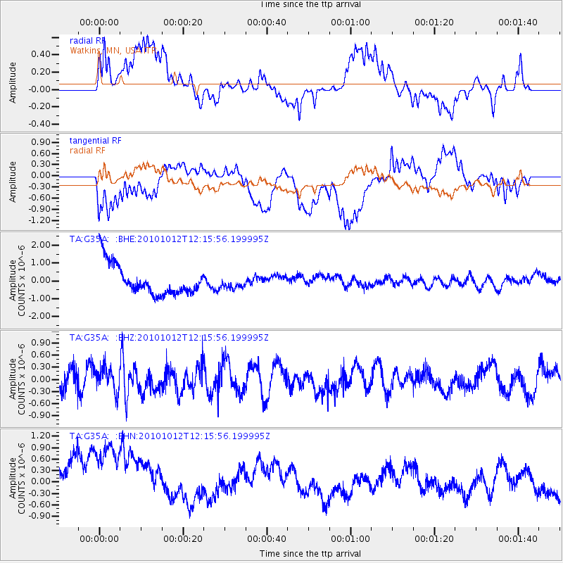
G35A Watkins, MN, USA - Earthquake Result Viewer
*The percent match for this event was below the threshold and hence no stack was calculated.
| Earthquake location: |
Tonga Islands |
| Earthquake latitude/longitude: |
-20.4/-174.1 |
| Earthquake time(UTC): |
2010/10/12 (285) 12:02:55 GMT |
| Earthquake Depth: |
12 km |
| Earthquake Magnitude: |
5.9 MB, 5.8 MS, 5.9 MW, 5.8 MW |
| Earthquake Catalog/Contributor: |
WHDF/NEIC |
|
| Network: |
TA USArray Transportable Network (new EarthScope stations) |
| Station: |
G35A Watkins, MN, USA |
| Lat/Lon: |
45.22 N/94.49 W |
| Elevation: |
361 m |
|
| Distance: |
97.2 deg |
| Az: |
44.479 deg |
| Baz: |
248.4 deg |
| Ray Param: |
$rayparam |
*The percent match for this event was below the threshold and hence was not used in the summary stack. |
|
| Radial Match: |
47.307293 % |
| Radial Bump: |
400 |
| Transverse Match: |
40.641453 % |
| Transverse Bump: |
400 |
| SOD ConfigId: |
339645 |
| Insert Time: |
2011-02-10 09:32:54.632 +0000 |
| GWidth: |
2.5 |
| Max Bumps: |
400 |
| Tol: |
0.001 |
|
Signal To Noise
| Channel | StoN | STA | LTA |
| TA:G35A: :BHZ:20101012T12:15:56.199995Z | 0.8727172 | 2.9227846E-7 | 3.3490625E-7 |
| TA:G35A: :BHN:20101012T12:15:56.199995Z | 1.0761677 | 2.3660975E-6 | 2.1986327E-6 |
| TA:G35A: :BHE:20101012T12:15:56.199995Z | 0.34070095 | 2.8822274E-7 | 8.4596985E-7 |
| Arrivals |
| Ps | |
| PpPs | |
| PsPs/PpSs | |


