You are here: Home > Network List > MN - MEDNET Project Stations List
> Station TIP Timpagrande, Italy > Earthquake Result Viewer
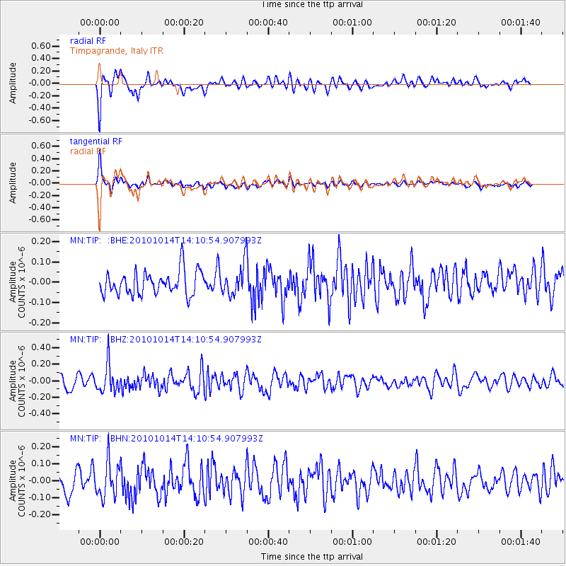
TIP Timpagrande, Italy - Earthquake Result Viewer
*The percent match for this event was below the threshold and hence no stack was calculated.
| Earthquake location: |
Hokkaido, Japan Region |
| Earthquake latitude/longitude: |
42.3/142.9 |
| Earthquake time(UTC): |
2010/10/14 (287) 13:58:55 GMT |
| Earthquake Depth: |
59 km |
| Earthquake Magnitude: |
5.6 MW, 5.2 MB |
| Earthquake Catalog/Contributor: |
WHDF/NEIC |
|
| Network: |
MN MEDNET Project |
| Station: |
TIP Timpagrande, Italy |
| Lat/Lon: |
39.18 N/16.76 E |
| Elevation: |
789 m |
|
| Distance: |
85.3 deg |
| Az: |
320.947 deg |
| Baz: |
36.96 deg |
| Ray Param: |
$rayparam |
*The percent match for this event was below the threshold and hence was not used in the summary stack. |
|
| Radial Match: |
69.797424 % |
| Radial Bump: |
400 |
| Transverse Match: |
81.53068 % |
| Transverse Bump: |
400 |
| SOD ConfigId: |
339645 |
| Insert Time: |
2011-02-10 09:41:14.237 +0000 |
| GWidth: |
2.5 |
| Max Bumps: |
400 |
| Tol: |
0.001 |
|
Signal To Noise
| Channel | StoN | STA | LTA |
| MN:TIP: :BHZ:20101014T14:10:54.907993Z | 2.3266604 | 1.7337348E-7 | 7.451603E-8 |
| MN:TIP: :BHN:20101014T14:10:54.907993Z | 1.4099388 | 1.0687366E-7 | 7.580021E-8 |
| MN:TIP: :BHE:20101014T14:10:54.907993Z | 1.3420334 | 7.802922E-8 | 5.8142533E-8 |
| Arrivals |
| Ps | |
| PpPs | |
| PsPs/PpSs | |


