You are here: Home > Network List > AV - Alaska Volcano Observatory Stations List
> Station AUW Augustine West, Cook Inlet, Alaska > Earthquake Result Viewer
AUW Augustine West, Cook Inlet, Alaska - Earthquake Result Viewer
| Earthquake location: |
Near East Coast Of Honshu, Japan |
| Earthquake latitude/longitude: |
37.7/141.9 |
| Earthquake time(UTC): |
2024/04/04 (095) 03:16:31 GMT |
| Earthquake Depth: |
40 km |
| Earthquake Magnitude: |
6.1 Mww |
| Earthquake Catalog/Contributor: |
NEIC PDE/us |
|
| Network: |
AV Alaska Volcano Observatory |
| Station: |
AUW Augustine West, Cook Inlet, Alaska |
| Lat/Lon: |
59.37 N/153.47 W |
| Elevation: |
276 m |
|
| Distance: |
45.8 deg |
| Az: |
40.2 deg |
| Baz: |
271.584 deg |
| Ray Param: |
0.07098018 |
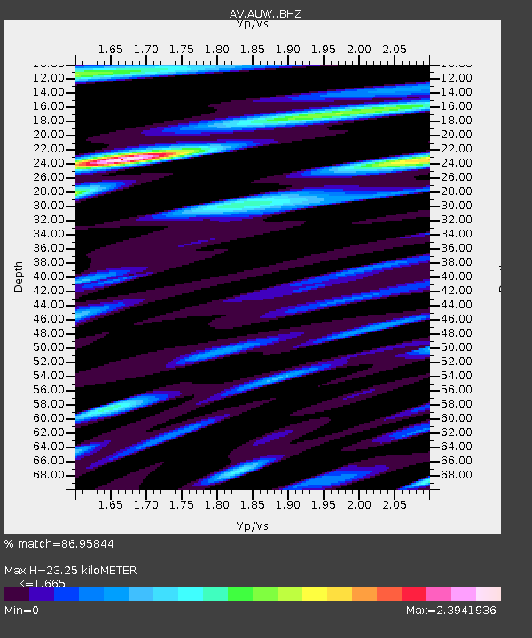
| Estimated Moho Depth: |
23.25 km |
| Estimated Crust Vp/Vs: |
1.66 |
| Assumed Crust Vp: |
5.989 km/s |
| Estimated Crust Vs: |
3.597 km/s |
| Estimated Crust Poisson's Ratio: |
0.22 |
|
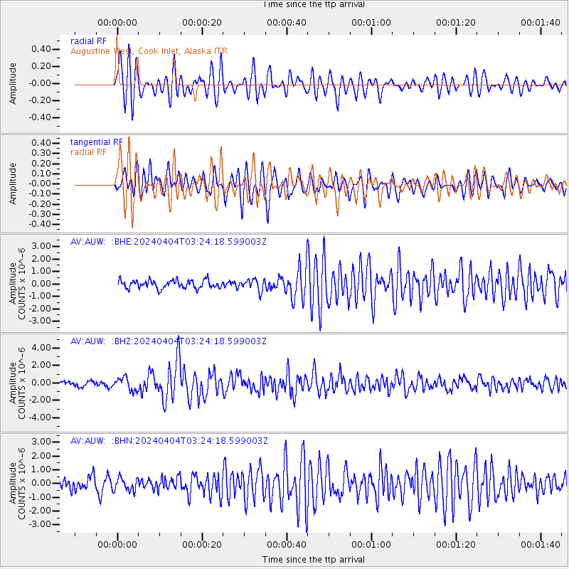
| Radial Match: |
86.95844 % |
| Radial Bump: |
400 |
| Transverse Match: |
81.26235 % |
| Transverse Bump: |
400 |
| SOD ConfigId: |
34025071 |
| Insert Time: |
2024-04-18 03:25:37.261 +0000 |
| GWidth: |
2.5 |
| Max Bumps: |
400 |
| Tol: |
0.001 |
|
Signal To Noise
| Channel | StoN | STA | LTA |
| AV:AUW: :BHZ:20240404T03:24:18.599003Z | 3.0740328 | 7.574355E-7 | 2.4639797E-7 |
| AV:AUW: :BHN:20240404T03:24:18.599003Z | 1.2514832 | 4.6787216E-7 | 3.738541E-7 |
| AV:AUW: :BHE:20240404T03:24:18.599003Z | 1.4466808 | 4.6575573E-7 | 3.2194782E-7 |
| Arrivals |
| Ps | 2.7 SECOND |
| PpPs | 9.8 SECOND |
| PsPs/PpSs | 12 SECOND |


