You are here: Home > Network List > C0 - Colorado Geological Survey Seismic Network Stations List
> Station LAMA Lamar Colorado > Earthquake Result Viewer
LAMA Lamar Colorado - Earthquake Result Viewer
| Earthquake location: |
Near East Coast Of Honshu, Japan |
| Earthquake latitude/longitude: |
37.7/141.9 |
| Earthquake time(UTC): |
2024/04/04 (095) 03:16:31 GMT |
| Earthquake Depth: |
40 km |
| Earthquake Magnitude: |
6.1 Mww |
| Earthquake Catalog/Contributor: |
NEIC PDE/us |
|
| Network: |
C0 Colorado Geological Survey Seismic Network |
| Station: |
LAMA Lamar Colorado |
| Lat/Lon: |
38.27 N/102.65 W |
| Elevation: |
1182 m |
|
| Distance: |
83.8 deg |
| Az: |
45.642 deg |
| Baz: |
313.916 deg |
| Ray Param: |
0.04586123 |
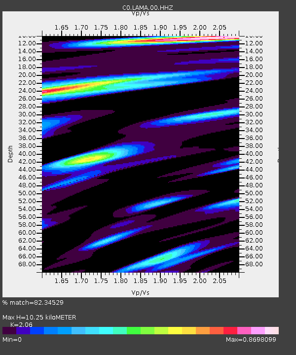
| Estimated Moho Depth: |
10.25 km |
| Estimated Crust Vp/Vs: |
2.06 |
| Assumed Crust Vp: |
6.242 km/s |
| Estimated Crust Vs: |
3.03 km/s |
| Estimated Crust Poisson's Ratio: |
0.35 |
|
| Radial Match: |
82.34529 % |
| Radial Bump: |
354 |
| Transverse Match: |
60.308075 % |
| Transverse Bump: |
400 |
| SOD ConfigId: |
34025071 |
| Insert Time: |
2024-04-18 03:28:14.337 +0000 |
| GWidth: |
2.5 |
| Max Bumps: |
400 |
| Tol: |
0.001 |
|

Signal To Noise
| Channel | StoN | STA | LTA |
| C0:LAMA:00:HHZ:20240404T03:28:25.519017Z | 2.6067004 | 7.592686E-7 | 2.9127574E-7 |
| C0:LAMA:00:HHN:20240404T03:28:25.519017Z | 0.5881724 | 1.9812755E-7 | 3.3685288E-7 |
| C0:LAMA:00:HHE:20240404T03:28:25.519017Z | 0.8184986 | 2.0316901E-7 | 2.4822157E-7 |
| Arrivals |
| Ps | 1.8 SECOND |
| PpPs | 4.9 SECOND |
| PsPs/PpSs | 6.7 SECOND |


