You are here: Home > Network List > TA - USArray Transportable Network (new EarthScope stations) Stations List
> Station C38A Sawbill Landing (USFS), Superior Nat. Forest, MN, > Earthquake Result Viewer
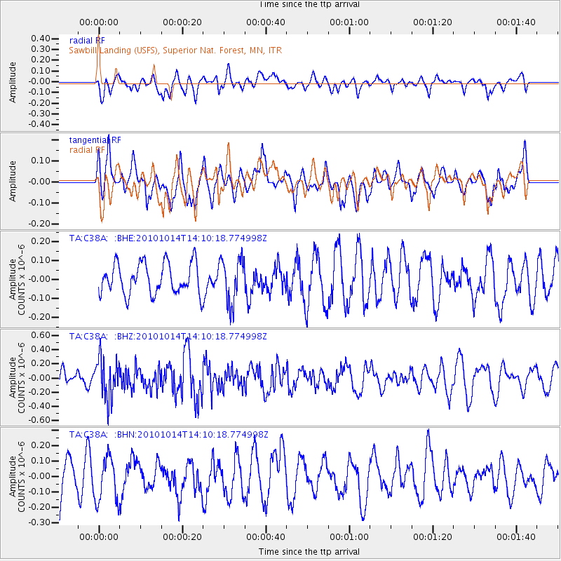
C38A Sawbill Landing (USFS), Superior Nat. Forest, MN, - Earthquake Result Viewer
*The percent match for this event was below the threshold and hence no stack was calculated.
| Earthquake location: |
Hokkaido, Japan Region |
| Earthquake latitude/longitude: |
42.3/142.9 |
| Earthquake time(UTC): |
2010/10/14 (287) 13:58:55 GMT |
| Earthquake Depth: |
59 km |
| Earthquake Magnitude: |
5.6 MW, 5.2 MB |
| Earthquake Catalog/Contributor: |
WHDF/NEIC |
|
| Network: |
TA USArray Transportable Network (new EarthScope stations) |
| Station: |
C38A Sawbill Landing (USFS), Superior Nat. Forest, MN, |
| Lat/Lon: |
47.72 N/91.27 W |
| Elevation: |
498 m |
|
| Distance: |
78.4 deg |
| Az: |
33.968 deg |
| Baz: |
322.139 deg |
| Ray Param: |
$rayparam |
*The percent match for this event was below the threshold and hence was not used in the summary stack. |
|
| Radial Match: |
57.179012 % |
| Radial Bump: |
400 |
| Transverse Match: |
68.56591 % |
| Transverse Bump: |
400 |
| SOD ConfigId: |
339645 |
| Insert Time: |
2011-02-10 09:48:18.014 +0000 |
| GWidth: |
2.5 |
| Max Bumps: |
400 |
| Tol: |
0.001 |
|
Signal To Noise
| Channel | StoN | STA | LTA |
| TA:C38A: :BHZ:20101014T14:10:18.774998Z | 2.9687586 | 2.8584586E-7 | 9.6284644E-8 |
| TA:C38A: :BHN:20101014T14:10:18.774998Z | 1.1262759 | 1.4883973E-7 | 1.321521E-7 |
| TA:C38A: :BHE:20101014T14:10:18.774998Z | 1.4586143 | 1.186619E-7 | 8.135249E-8 |
| Arrivals |
| Ps | |
| PpPs | |
| PsPs/PpSs | |


