You are here: Home > Network List > US - United States National Seismic Network Stations List
> Station MIAR Mount Ida, Arkansas, USA > Earthquake Result Viewer
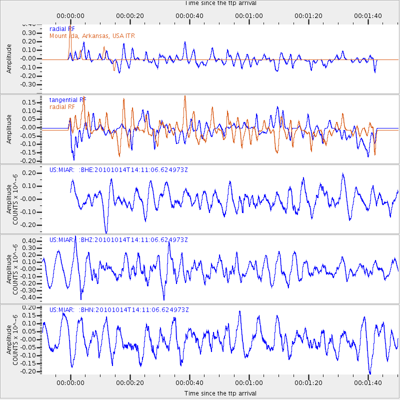
MIAR Mount Ida, Arkansas, USA - Earthquake Result Viewer
*The percent match for this event was below the threshold and hence no stack was calculated.
| Earthquake location: |
Hokkaido, Japan Region |
| Earthquake latitude/longitude: |
42.3/142.9 |
| Earthquake time(UTC): |
2010/10/14 (287) 13:58:55 GMT |
| Earthquake Depth: |
59 km |
| Earthquake Magnitude: |
5.6 MW, 5.2 MB |
| Earthquake Catalog/Contributor: |
WHDF/NEIC |
|
| Network: |
US United States National Seismic Network |
| Station: |
MIAR Mount Ida, Arkansas, USA |
| Lat/Lon: |
34.55 N/93.58 W |
| Elevation: |
207 m |
|
| Distance: |
87.7 deg |
| Az: |
43.509 deg |
| Baz: |
321.782 deg |
| Ray Param: |
$rayparam |
*The percent match for this event was below the threshold and hence was not used in the summary stack. |
|
| Radial Match: |
58.16509 % |
| Radial Bump: |
400 |
| Transverse Match: |
44.539284 % |
| Transverse Bump: |
400 |
| SOD ConfigId: |
339645 |
| Insert Time: |
2011-02-10 09:48:33.047 +0000 |
| GWidth: |
2.5 |
| Max Bumps: |
400 |
| Tol: |
0.001 |
|
Signal To Noise
| Channel | StoN | STA | LTA |
| US:MIAR: :BHZ:20101014T14:11:06.624973Z | 2.2425628 | 2.3949687E-7 | 1.0679605E-7 |
| US:MIAR: :BHN:20101014T14:11:06.624973Z | 1.6354423 | 1.0326227E-7 | 6.314028E-8 |
| US:MIAR: :BHE:20101014T14:11:06.624973Z | 0.9805785 | 7.369348E-8 | 7.515306E-8 |
| Arrivals |
| Ps | |
| PpPs | |
| PsPs/PpSs | |


