You are here: Home > Network List > US - United States National Seismic Network Stations List
> Station WUAZ Wupatki, Arizona, USA > Earthquake Result Viewer
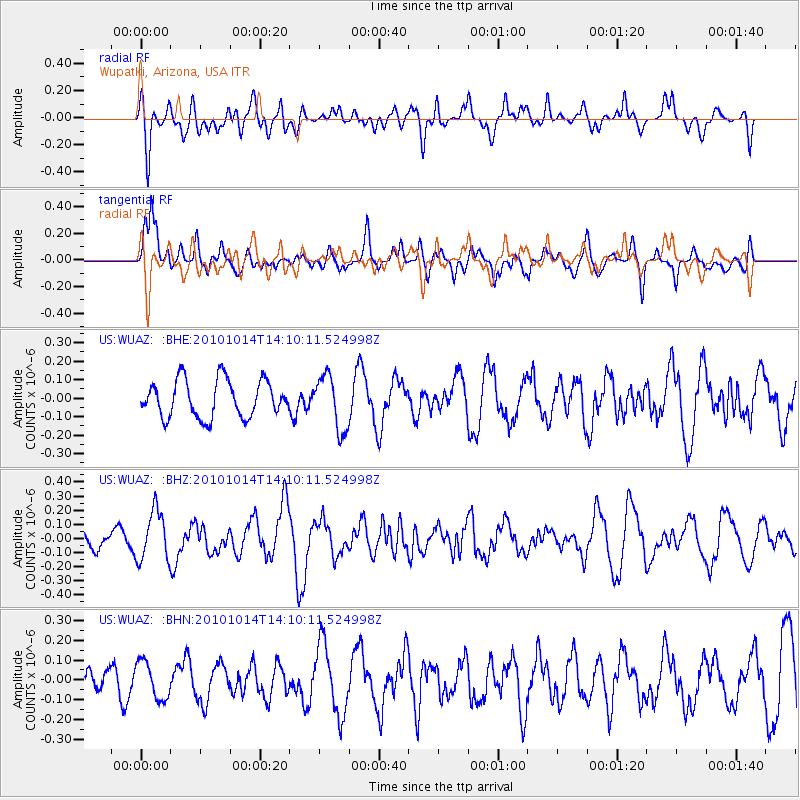
WUAZ Wupatki, Arizona, USA - Earthquake Result Viewer
*The percent match for this event was below the threshold and hence no stack was calculated.
| Earthquake location: |
Hokkaido, Japan Region |
| Earthquake latitude/longitude: |
42.3/142.9 |
| Earthquake time(UTC): |
2010/10/14 (287) 13:58:55 GMT |
| Earthquake Depth: |
59 km |
| Earthquake Magnitude: |
5.6 MW, 5.2 MB |
| Earthquake Catalog/Contributor: |
WHDF/NEIC |
|
| Network: |
US United States National Seismic Network |
| Station: |
WUAZ Wupatki, Arizona, USA |
| Lat/Lon: |
35.52 N/111.37 W |
| Elevation: |
1592 m |
|
| Distance: |
77.1 deg |
| Az: |
53.661 deg |
| Baz: |
312.91 deg |
| Ray Param: |
$rayparam |
*The percent match for this event was below the threshold and hence was not used in the summary stack. |
|
| Radial Match: |
60.154232 % |
| Radial Bump: |
400 |
| Transverse Match: |
72.84709 % |
| Transverse Bump: |
400 |
| SOD ConfigId: |
339645 |
| Insert Time: |
2011-02-10 09:48:51.454 +0000 |
| GWidth: |
2.5 |
| Max Bumps: |
400 |
| Tol: |
0.001 |
|
Signal To Noise
| Channel | StoN | STA | LTA |
| US:WUAZ: :BHZ:20101014T14:10:11.524998Z | 3.2200184 | 1.7526887E-7 | 5.4431013E-8 |
| US:WUAZ: :BHN:20101014T14:10:11.524998Z | 1.1842068 | 9.468643E-8 | 7.995768E-8 |
| US:WUAZ: :BHE:20101014T14:10:11.524998Z | 1.4793255 | 1.4807696E-7 | 1.0009762E-7 |
| Arrivals |
| Ps | |
| PpPs | |
| PsPs/PpSs | |


