You are here: Home > Network List > KO - Kandilli Observatory Digital Broadband Seismic Network Stations List
> Station SNOP Sinop-Turkey > Earthquake Result Viewer
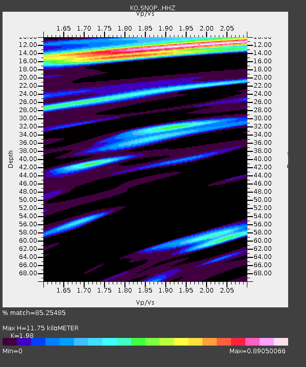
SNOP Sinop-Turkey - Earthquake Result Viewer
| Earthquake location: |
Near East Coast Of Honshu, Japan |
| Earthquake latitude/longitude: |
37.7/141.9 |
| Earthquake time(UTC): |
2024/04/04 (095) 03:16:31 GMT |
| Earthquake Depth: |
40 km |
| Earthquake Magnitude: |
6.1 Mww |
| Earthquake Catalog/Contributor: |
NEIC PDE/us |
|
| Network: |
KO Kandilli Observatory Digital Broadband Seismic Network |
| Station: |
SNOP Sinop-Turkey |
| Lat/Lon: |
42.02 N/35.21 E |
| Elevation: |
180 m |
|
| Distance: |
76.3 deg |
| Az: |
312.739 deg |
| Baz: |
51.409 deg |
| Ray Param: |
0.05100999 |
| Estimated Moho Depth: |
11.75 km |
| Estimated Crust Vp/Vs: |
1.98 |
| Assumed Crust Vp: |
5.806 km/s |
| Estimated Crust Vs: |
2.932 km/s |
| Estimated Crust Poisson's Ratio: |
0.33 |
|
| Radial Match: |
85.25485 % |
| Radial Bump: |
400 |
| Transverse Match: |
82.36579 % |
| Transverse Bump: |
400 |
| SOD ConfigId: |
34025071 |
| Insert Time: |
2024-04-18 03:38:27.040 +0000 |
| GWidth: |
2.5 |
| Max Bumps: |
400 |
| Tol: |
0.001 |
|

Signal To Noise
| Channel | StoN | STA | LTA |
| KO:SNOP: :HHZ:20240404T03:27:45.319981Z | 15.576321 | 2.277238E-6 | 1.4619872E-7 |
| KO:SNOP: :HHN:20240404T03:27:45.319981Z | 4.3745985 | 5.828805E-7 | 1.3324205E-7 |
| KO:SNOP: :HHE:20240404T03:27:45.319981Z | 5.5319977 | 7.133996E-7 | 1.2895876E-7 |
| Arrivals |
| Ps | 2.0 SECOND |
| PpPs | 5.9 SECOND |
| PsPs/PpSs | 7.9 SECOND |


