You are here: Home > Network List > KR - Kyrgyz Digital Network Stations List
> Station BOOM Boom, Kyrgyzstan > Earthquake Result Viewer
BOOM Boom, Kyrgyzstan - Earthquake Result Viewer
| Earthquake location: |
Near East Coast Of Honshu, Japan |
| Earthquake latitude/longitude: |
37.7/141.9 |
| Earthquake time(UTC): |
2024/04/04 (095) 03:16:31 GMT |
| Earthquake Depth: |
40 km |
| Earthquake Magnitude: |
6.1 Mww |
| Earthquake Catalog/Contributor: |
NEIC PDE/us |
|
| Network: |
KR Kyrgyz Digital Network |
| Station: |
BOOM Boom, Kyrgyzstan |
| Lat/Lon: |
42.49 N/75.94 E |
| Elevation: |
1737 m |
|
| Distance: |
49.6 deg |
| Az: |
297.405 deg |
| Baz: |
72.139 deg |
| Ray Param: |
0.06855491 |
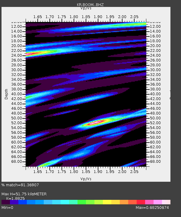
| Estimated Moho Depth: |
51.75 km |
| Estimated Crust Vp/Vs: |
1.88 |
| Assumed Crust Vp: |
6.306 km/s |
| Estimated Crust Vs: |
3.35 km/s |
| Estimated Crust Poisson's Ratio: |
0.30 |
|
| Radial Match: |
91.36907 % |
| Radial Bump: |
400 |
| Transverse Match: |
79.03673 % |
| Transverse Bump: |
400 |
| SOD ConfigId: |
34025071 |
| Insert Time: |
2024-04-18 03:39:12.662 +0000 |
| GWidth: |
2.5 |
| Max Bumps: |
400 |
| Tol: |
0.001 |
|

Signal To Noise
| Channel | StoN | STA | LTA |
| KR:BOOM: :BHZ:20240404T03:24:47.820011Z | 19.304781 | 1.9171905E-6 | 9.9311684E-8 |
| KR:BOOM: :BHN:20240404T03:24:47.820011Z | 11.817239 | 4.659122E-7 | 3.942649E-8 |
| KR:BOOM: :BHE:20240404T03:24:47.820011Z | 20.72638 | 8.1629713E-7 | 3.9384453E-8 |
| Arrivals |
| Ps | 7.6 SECOND |
| PpPs | 22 SECOND |
| PsPs/PpSs | 30 SECOND |


