You are here: Home > Network List > KR - Kyrgyz Digital Network Stations List
> Station SALK Salom-Alik, Kyrgyzstan > Earthquake Result Viewer
SALK Salom-Alik, Kyrgyzstan - Earthquake Result Viewer
| Earthquake location: |
Near East Coast Of Honshu, Japan |
| Earthquake latitude/longitude: |
37.7/141.9 |
| Earthquake time(UTC): |
2024/04/04 (095) 03:16:31 GMT |
| Earthquake Depth: |
40 km |
| Earthquake Magnitude: |
6.1 Mww |
| Earthquake Catalog/Contributor: |
NEIC PDE/us |
|
| Network: |
KR Kyrgyz Digital Network |
| Station: |
SALK Salom-Alik, Kyrgyzstan |
| Lat/Lon: |
40.88 N/73.82 E |
| Elevation: |
1672 m |
|
| Distance: |
51.6 deg |
| Az: |
296.108 deg |
| Baz: |
69.911 deg |
| Ray Param: |
0.06723957 |
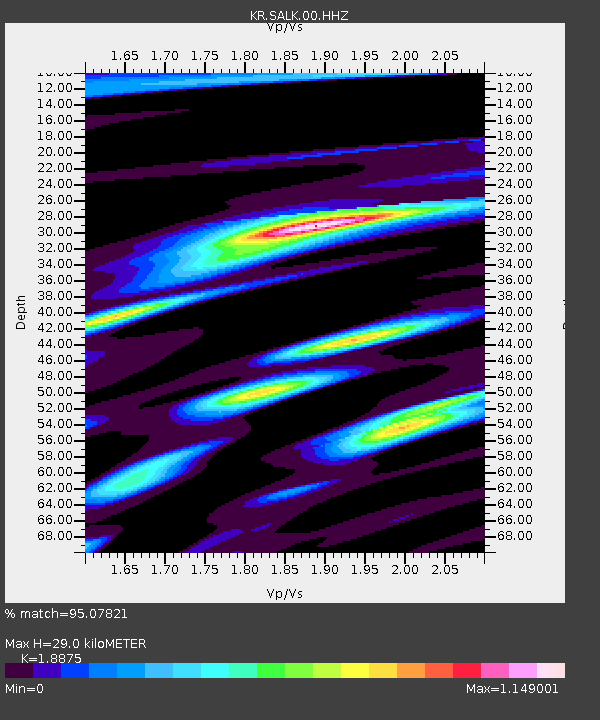
| Estimated Moho Depth: |
29.0 km |
| Estimated Crust Vp/Vs: |
1.89 |
| Assumed Crust Vp: |
6.306 km/s |
| Estimated Crust Vs: |
3.341 km/s |
| Estimated Crust Poisson's Ratio: |
0.30 |
|
| Radial Match: |
95.07821 % |
| Radial Bump: |
400 |
| Transverse Match: |
91.50715 % |
| Transverse Bump: |
400 |
| SOD ConfigId: |
34025071 |
| Insert Time: |
2024-04-18 03:39:29.011 +0000 |
| GWidth: |
2.5 |
| Max Bumps: |
400 |
| Tol: |
0.001 |
|

Signal To Noise
| Channel | StoN | STA | LTA |
| KR:SALK:00:HHZ:20240404T03:25:03.10001Z | 35.57936 | 1.8879838E-6 | 5.3064017E-8 |
| KR:SALK:00:HHN:20240404T03:25:03.10001Z | 5.328138 | 2.028266E-7 | 3.806707E-8 |
| KR:SALK:00:HHE:20240404T03:25:03.10001Z | 39.686916 | 1.0764722E-6 | 2.712411E-8 |
| Arrivals |
| Ps | 4.3 SECOND |
| PpPs | 13 SECOND |
| PsPs/PpSs | 17 SECOND |


