You are here: Home > Network List > AU - Australian Seismological Centre Stations List
> Station MANU Manus Island, Papau New Guinea > Earthquake Result Viewer
MANU Manus Island, Papau New Guinea - Earthquake Result Viewer
| Earthquake location: |
Tonga Islands |
| Earthquake latitude/longitude: |
-20.5/-173.9 |
| Earthquake time(UTC): |
2010/10/16 (289) 13:27:45 GMT |
| Earthquake Depth: |
7.4 km |
| Earthquake Magnitude: |
5.7 MB, 5.7 MS, 5.6 MW, 5.6 MW |
| Earthquake Catalog/Contributor: |
WHDF/NEIC |
|
| Network: |
AU Australian Seismological Centre |
| Station: |
MANU Manus Island, Papau New Guinea |
| Lat/Lon: |
2.04 S/147.37 E |
| Elevation: |
142 m |
|
| Distance: |
42.0 deg |
| Az: |
290.824 deg |
| Baz: |
118.72 deg |
| Ray Param: |
0.07345876 |
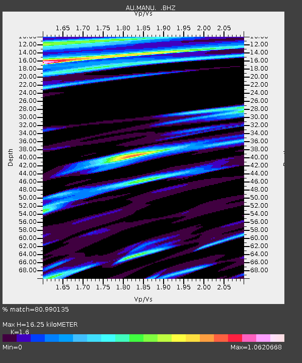
| Estimated Moho Depth: |
16.25 km |
| Estimated Crust Vp/Vs: |
1.60 |
| Assumed Crust Vp: |
4.082 km/s |
| Estimated Crust Vs: |
2.551 km/s |
| Estimated Crust Poisson's Ratio: |
0.18 |
|
| Radial Match: |
80.990135 % |
| Radial Bump: |
400 |
| Transverse Match: |
73.3883 % |
| Transverse Bump: |
400 |
| SOD ConfigId: |
339645 |
| Insert Time: |
2011-02-17 07:37:18.282 +0000 |
| GWidth: |
2.5 |
| Max Bumps: |
400 |
| Tol: |
0.001 |
|

Signal To Noise
| Channel | StoN | STA | LTA |
| AU:MANU: :BHZ:20101016T13:35:06.295011Z | 8.975288 | 9.340726E-7 | 1.040716E-7 |
| AU:MANU: :BHN:20101016T13:35:06.295011Z | 3.1483073 | 3.73083E-7 | 1.18502726E-7 |
| AU:MANU: :BHE:20101016T13:35:06.295011Z | 2.6186616 | 3.3812097E-7 | 1.2911977E-7 |
| Arrivals |
| Ps | 2.5 SECOND |
| PpPs | 10 SECOND |
| PsPs/PpSs | 13 SECOND |


