You are here: Home > Network List > US - United States National Seismic Network Stations List
> Station CBKS Cedar Bluff, Kansas, USA > Earthquake Result Viewer
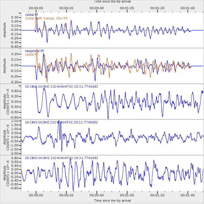
CBKS Cedar Bluff, Kansas, USA - Earthquake Result Viewer
*The percent match for this event was below the threshold and hence no stack was calculated.
| Earthquake location: |
Near East Coast Of Honshu, Japan |
| Earthquake latitude/longitude: |
37.7/141.9 |
| Earthquake time(UTC): |
2024/04/04 (095) 03:16:31 GMT |
| Earthquake Depth: |
40 km |
| Earthquake Magnitude: |
6.1 Mww |
| Earthquake Catalog/Contributor: |
NEIC PDE/us |
|
| Network: |
US United States National Seismic Network |
| Station: |
CBKS Cedar Bluff, Kansas, USA |
| Lat/Lon: |
38.81 N/99.74 W |
| Elevation: |
677 m |
|
| Distance: |
85.1 deg |
| Az: |
43.644 deg |
| Baz: |
315.527 deg |
| Ray Param: |
$rayparam |
*The percent match for this event was below the threshold and hence was not used in the summary stack. |
|
| Radial Match: |
59.624 % |
| Radial Bump: |
400 |
| Transverse Match: |
48.66541 % |
| Transverse Bump: |
400 |
| SOD ConfigId: |
34025071 |
| Insert Time: |
2024-04-18 03:53:11.906 +0000 |
| GWidth: |
2.5 |
| Max Bumps: |
400 |
| Tol: |
0.001 |
|
Signal To Noise
| Channel | StoN | STA | LTA |
| US:CBKS:00:BHZ:20240404T03:28:31.774998Z | 2.2377071 | 6.094784E-7 | 2.7236737E-7 |
| US:CBKS:00:BH1:20240404T03:28:31.774998Z | 0.9913142 | 2.5982607E-7 | 2.6210265E-7 |
| US:CBKS:00:BH2:20240404T03:28:31.774998Z | 0.6654317 | 2.572566E-7 | 3.866011E-7 |
| Arrivals |
| Ps | |
| PpPs | |
| PsPs/PpSs | |


