You are here: Home > Network List > CI - Caltech Regional Seismic Network Stations List
> Station SWS Sam W. Stewart, Westmorland, CA, USA > Earthquake Result Viewer
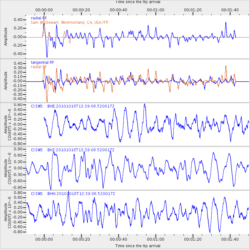
SWS Sam W. Stewart, Westmorland, CA, USA - Earthquake Result Viewer
*The percent match for this event was below the threshold and hence no stack was calculated.
| Earthquake location: |
Tonga Islands |
| Earthquake latitude/longitude: |
-20.5/-173.9 |
| Earthquake time(UTC): |
2010/10/16 (289) 13:27:45 GMT |
| Earthquake Depth: |
7.4 km |
| Earthquake Magnitude: |
5.7 MB, 5.7 MS, 5.6 MW, 5.6 MW |
| Earthquake Catalog/Contributor: |
WHDF/NEIC |
|
| Network: |
CI Caltech Regional Seismic Network |
| Station: |
SWS Sam W. Stewart, Westmorland, CA, USA |
| Lat/Lon: |
32.94 N/115.80 W |
| Elevation: |
140 m |
|
| Distance: |
76.8 deg |
| Az: |
47.175 deg |
| Baz: |
234.87 deg |
| Ray Param: |
$rayparam |
*The percent match for this event was below the threshold and hence was not used in the summary stack. |
|
| Radial Match: |
59.18738 % |
| Radial Bump: |
332 |
| Transverse Match: |
76.05027 % |
| Transverse Bump: |
372 |
| SOD ConfigId: |
339645 |
| Insert Time: |
2011-02-17 07:39:37.977 +0000 |
| GWidth: |
2.5 |
| Max Bumps: |
400 |
| Tol: |
0.001 |
|
Signal To Noise
| Channel | StoN | STA | LTA |
| CI:SWS: :BHZ:20101016T13:39:06.520017Z | 2.1604123 | 4.4063415E-7 | 2.0395835E-7 |
| CI:SWS: :BHN:20101016T13:39:06.520017Z | 0.7972687 | 1.666216E-7 | 2.0899053E-7 |
| CI:SWS: :BHE:20101016T13:39:06.520017Z | 0.99491274 | 2.6146245E-7 | 2.6279938E-7 |
| Arrivals |
| Ps | |
| PpPs | |
| PsPs/PpSs | |


