You are here: Home > Network List > UU - University of Utah Regional Network Stations List
> Station FORU South Mineral Mountains, UT, USA > Earthquake Result Viewer
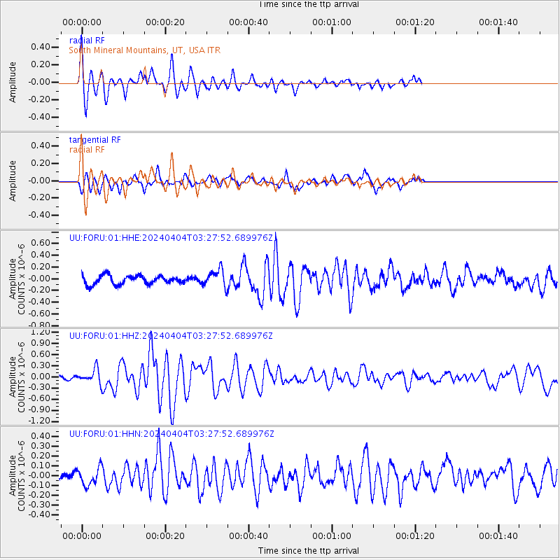
FORU South Mineral Mountains, UT, USA - Earthquake Result Viewer
*The percent match for this event was below the threshold and hence no stack was calculated.
| Earthquake location: |
Near East Coast Of Honshu, Japan |
| Earthquake latitude/longitude: |
37.7/141.9 |
| Earthquake time(UTC): |
2024/04/04 (095) 03:16:31 GMT |
| Earthquake Depth: |
40 km |
| Earthquake Magnitude: |
6.1 Mww |
| Earthquake Catalog/Contributor: |
NEIC PDE/us |
|
| Network: |
UU University of Utah Regional Network |
| Station: |
FORU South Mineral Mountains, UT, USA |
| Lat/Lon: |
38.46 N/112.86 W |
| Elevation: |
1840 m |
|
| Distance: |
77.6 deg |
| Az: |
50.853 deg |
| Baz: |
308.432 deg |
| Ray Param: |
$rayparam |
*The percent match for this event was below the threshold and hence was not used in the summary stack. |
|
| Radial Match: |
75.20934 % |
| Radial Bump: |
400 |
| Transverse Match: |
73.258125 % |
| Transverse Bump: |
400 |
| SOD ConfigId: |
34025071 |
| Insert Time: |
2024-04-18 03:54:12.924 +0000 |
| GWidth: |
2.5 |
| Max Bumps: |
400 |
| Tol: |
0.001 |
|
Signal To Noise
| Channel | StoN | STA | LTA |
| UU:FORU:01:HHZ:20240404T03:27:52.689976Z | 3.404043 | 1.9222486E-7 | 5.6469574E-8 |
| UU:FORU:01:HHN:20240404T03:27:52.689976Z | 0.9138598 | 8.866962E-8 | 9.70276E-8 |
| UU:FORU:01:HHE:20240404T03:27:52.689976Z | 1.9855989 | 1.4849729E-7 | 7.478715E-8 |
| Arrivals |
| Ps | |
| PpPs | |
| PsPs/PpSs | |


