You are here: Home > Network List > 1E - GSC-BCOGC Induced Seismicity Study Stations List
> Station BCH1A Z > Earthquake Result Viewer
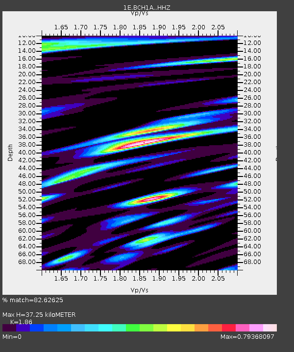
BCH1A Z - Earthquake Result Viewer
| Earthquake location: |
Mariana Islands |
| Earthquake latitude/longitude: |
19.1/145.4 |
| Earthquake time(UTC): |
2024/04/05 (096) 11:03:16 GMT |
| Earthquake Depth: |
222 km |
| Earthquake Magnitude: |
6.8 mww |
| Earthquake Catalog/Contributor: |
NEIC PDE/us |
|
| Network: |
1E GSC-BCOGC Induced Seismicity Study |
| Station: |
BCH1A Z |
| Lat/Lon: |
55.83 N/120.26 W |
| Elevation: |
689 m |
|
| Distance: |
76.8 deg |
| Az: |
35.296 deg |
| Baz: |
284.441 deg |
| Ray Param: |
0.05017303 |
| Estimated Moho Depth: |
37.25 km |
| Estimated Crust Vp/Vs: |
1.86 |
| Assumed Crust Vp: |
6.303 km/s |
| Estimated Crust Vs: |
3.388 km/s |
| Estimated Crust Poisson's Ratio: |
0.30 |
|
| Radial Match: |
82.62625 % |
| Radial Bump: |
400 |
| Transverse Match: |
78.78296 % |
| Transverse Bump: |
400 |
| SOD ConfigId: |
34025071 |
| Insert Time: |
2024-04-19 11:04:45.752 +0000 |
| GWidth: |
2.5 |
| Max Bumps: |
400 |
| Tol: |
0.001 |
|

Signal To Noise
| Channel | StoN | STA | LTA |
| 1E:BCH1A: :HHZ:20240405T11:14:12.449981Z | 70.88612 | 1.2947609E-5 | 1.8265366E-7 |
| 1E:BCH1A: :HHN:20240405T11:14:12.449981Z | 3.6532054 | 1.4083631E-6 | 3.8551434E-7 |
| 1E:BCH1A: :HHE:20240405T11:14:12.449981Z | 9.407405 | 4.142863E-6 | 4.4038322E-7 |
| Arrivals |
| Ps | 5.2 SECOND |
| PpPs | 16 SECOND |
| PsPs/PpSs | 22 SECOND |


