You are here: Home > Network List > 1E - GSC-BCOGC Induced Seismicity Study Stations List
> Station MONT8 Z > Earthquake Result Viewer
MONT8 Z - Earthquake Result Viewer
| Earthquake location: |
Mariana Islands |
| Earthquake latitude/longitude: |
19.1/145.4 |
| Earthquake time(UTC): |
2024/04/05 (096) 11:03:16 GMT |
| Earthquake Depth: |
222 km |
| Earthquake Magnitude: |
6.8 mww |
| Earthquake Catalog/Contributor: |
NEIC PDE/us |
|
| Network: |
1E GSC-BCOGC Induced Seismicity Study |
| Station: |
MONT8 Z |
| Lat/Lon: |
56.07 N/120.78 W |
| Elevation: |
695 m |
|
| Distance: |
76.5 deg |
| Az: |
35.135 deg |
| Baz: |
283.975 deg |
| Ray Param: |
0.050391324 |
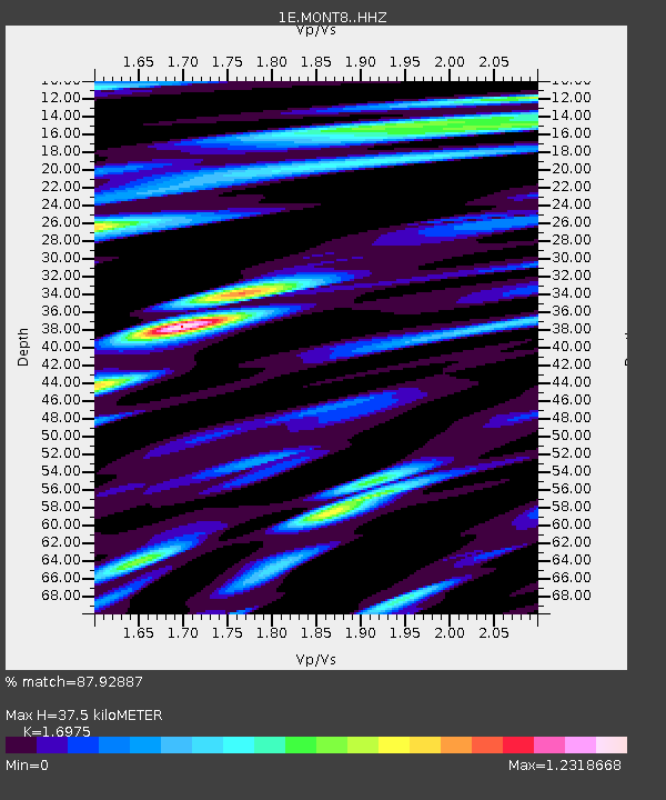
| Estimated Moho Depth: |
37.5 km |
| Estimated Crust Vp/Vs: |
1.70 |
| Assumed Crust Vp: |
6.291 km/s |
| Estimated Crust Vs: |
3.706 km/s |
| Estimated Crust Poisson's Ratio: |
0.23 |
|
| Radial Match: |
87.92887 % |
| Radial Bump: |
400 |
| Transverse Match: |
75.361176 % |
| Transverse Bump: |
400 |
| SOD ConfigId: |
34025071 |
| Insert Time: |
2024-04-19 11:04:58.887 +0000 |
| GWidth: |
2.5 |
| Max Bumps: |
400 |
| Tol: |
0.001 |
|

Signal To Noise
| Channel | StoN | STA | LTA |
| 1E:MONT8: :HHZ:20240405T11:14:10.560028Z | 95.957085 | 1.7553026E-5 | 1.829258E-7 |
| 1E:MONT8: :HHN:20240405T11:14:10.560028Z | 15.330984 | 3.882675E-6 | 2.5325676E-7 |
| 1E:MONT8: :HHE:20240405T11:14:10.560028Z | 35.205517 | 6.076235E-6 | 1.7259326E-7 |
| Arrivals |
| Ps | 4.3 SECOND |
| PpPs | 16 SECOND |
| PsPs/PpSs | 20 SECOND |


