You are here: Home > Network List > AK - Alaska Regional Network Stations List
> Station NEA2 Nenana, AK, USA > Earthquake Result Viewer
NEA2 Nenana, AK, USA - Earthquake Result Viewer
| Earthquake location: |
Mariana Islands |
| Earthquake latitude/longitude: |
19.1/145.4 |
| Earthquake time(UTC): |
2024/04/05 (096) 11:03:16 GMT |
| Earthquake Depth: |
222 km |
| Earthquake Magnitude: |
6.8 mww |
| Earthquake Catalog/Contributor: |
NEIC PDE/us |
|
| Network: |
AK Alaska Regional Network |
| Station: |
NEA2 Nenana, AK, USA |
| Lat/Lon: |
64.59 N/149.07 W |
| Elevation: |
450 m |
|
| Distance: |
62.5 deg |
| Az: |
26.288 deg |
| Baz: |
256.111 deg |
| Ray Param: |
0.059525788 |
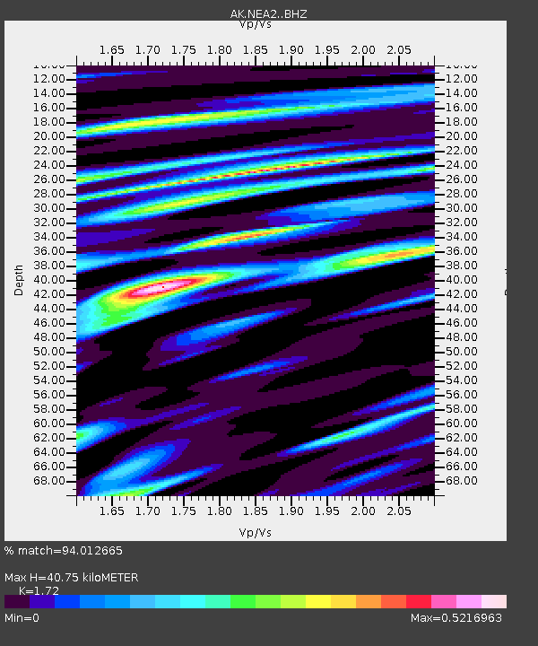
| Estimated Moho Depth: |
40.75 km |
| Estimated Crust Vp/Vs: |
1.72 |
| Assumed Crust Vp: |
6.566 km/s |
| Estimated Crust Vs: |
3.818 km/s |
| Estimated Crust Poisson's Ratio: |
0.24 |
|
| Radial Match: |
94.012665 % |
| Radial Bump: |
400 |
| Transverse Match: |
84.605064 % |
| Transverse Bump: |
400 |
| SOD ConfigId: |
34025071 |
| Insert Time: |
2024-04-19 11:09:11.712 +0000 |
| GWidth: |
2.5 |
| Max Bumps: |
400 |
| Tol: |
0.001 |
|

Signal To Noise
| Channel | StoN | STA | LTA |
| AK:NEA2: :BHZ:20240405T11:12:45.167999Z | 56.658176 | 9.007185E-6 | 1.5897415E-7 |
| AK:NEA2: :BHN:20240405T11:12:45.167999Z | 12.45349 | 2.1302083E-6 | 1.710531E-7 |
| AK:NEA2: :BHE:20240405T11:12:45.167999Z | 17.847181 | 3.3552512E-6 | 1.8799894E-7 |
| Arrivals |
| Ps | 4.7 SECOND |
| PpPs | 16 SECOND |
| PsPs/PpSs | 21 SECOND |


