You are here: Home > Network List > AK - Alaska Regional Network Stations List
> Station PAX Paxson > Earthquake Result Viewer
PAX Paxson - Earthquake Result Viewer
| Earthquake location: |
Mariana Islands |
| Earthquake latitude/longitude: |
19.1/145.4 |
| Earthquake time(UTC): |
2024/04/05 (096) 11:03:16 GMT |
| Earthquake Depth: |
222 km |
| Earthquake Magnitude: |
6.8 mww |
| Earthquake Catalog/Contributor: |
NEIC PDE/us |
|
| Network: |
AK Alaska Regional Network |
| Station: |
PAX Paxson |
| Lat/Lon: |
62.97 N/145.47 W |
| Elevation: |
1130 m |
|
| Distance: |
63.7 deg |
| Az: |
28.442 deg |
| Baz: |
260.314 deg |
| Ray Param: |
0.05873206 |
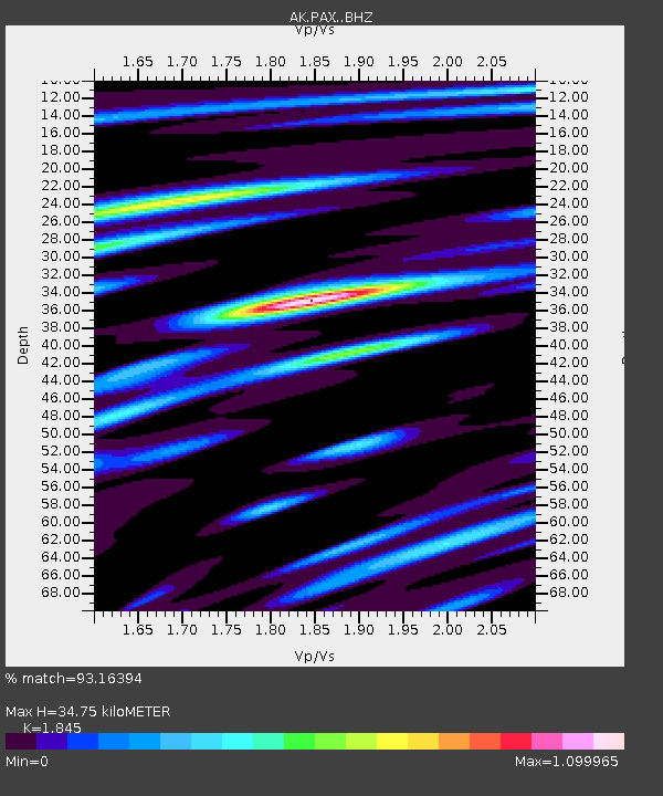
| Estimated Moho Depth: |
34.75 km |
| Estimated Crust Vp/Vs: |
1.85 |
| Assumed Crust Vp: |
6.566 km/s |
| Estimated Crust Vs: |
3.559 km/s |
| Estimated Crust Poisson's Ratio: |
0.29 |
|
| Radial Match: |
93.16394 % |
| Radial Bump: |
400 |
| Transverse Match: |
79.104706 % |
| Transverse Bump: |
400 |
| SOD ConfigId: |
34025071 |
| Insert Time: |
2024-04-19 11:09:24.004 +0000 |
| GWidth: |
2.5 |
| Max Bumps: |
400 |
| Tol: |
0.001 |
|

Signal To Noise
| Channel | StoN | STA | LTA |
| AK:PAX: :BHZ:20240405T11:12:53.248016Z | 110.78271 | 9.269231E-6 | 8.367037E-8 |
| AK:PAX: :BHN:20240405T11:12:53.248016Z | 6.0452228 | 1.733296E-6 | 2.8672162E-7 |
| AK:PAX: :BHE:20240405T11:12:53.248016Z | 14.792 | 4.6282526E-6 | 3.1288891E-7 |
| Arrivals |
| Ps | 4.7 SECOND |
| PpPs | 14 SECOND |
| PsPs/PpSs | 19 SECOND |


