You are here: Home > Network List > AK - Alaska Regional Network Stations List
> Station SII Sitkinak Island Coast Guard > Earthquake Result Viewer
SII Sitkinak Island Coast Guard - Earthquake Result Viewer
| Earthquake location: |
Mariana Islands |
| Earthquake latitude/longitude: |
19.1/145.4 |
| Earthquake time(UTC): |
2024/04/05 (096) 11:03:16 GMT |
| Earthquake Depth: |
222 km |
| Earthquake Magnitude: |
6.8 mww |
| Earthquake Catalog/Contributor: |
NEIC PDE/us |
|
| Network: |
AK Alaska Regional Network |
| Station: |
SII Sitkinak Island Coast Guard |
| Lat/Lon: |
56.56 N/154.18 W |
| Elevation: |
465 m |
|
| Distance: |
58.0 deg |
| Az: |
34.579 deg |
| Baz: |
255.774 deg |
| Ray Param: |
0.062366523 |
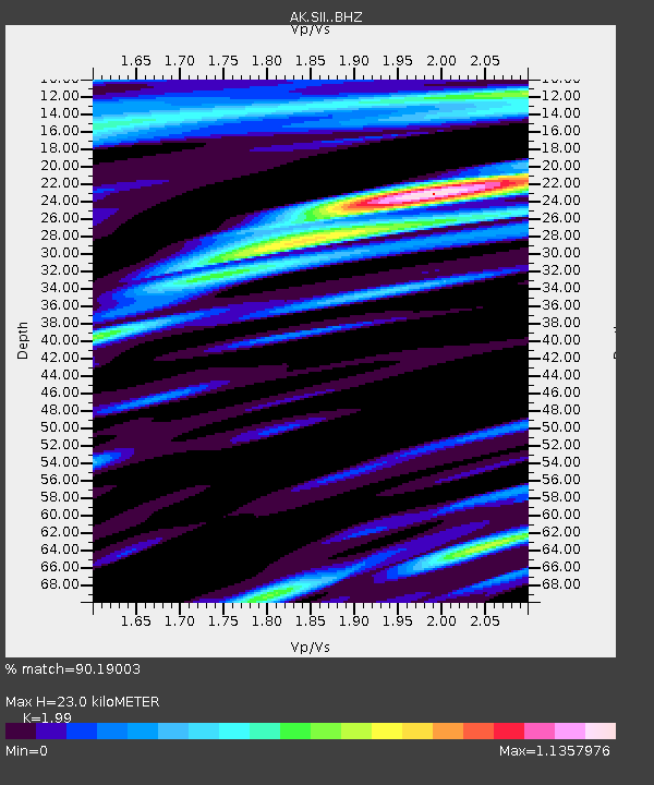
| Estimated Moho Depth: |
23.0 km |
| Estimated Crust Vp/Vs: |
1.99 |
| Assumed Crust Vp: |
6.24 km/s |
| Estimated Crust Vs: |
3.136 km/s |
| Estimated Crust Poisson's Ratio: |
0.33 |
|
| Radial Match: |
90.19003 % |
| Radial Bump: |
400 |
| Transverse Match: |
83.22915 % |
| Transverse Bump: |
400 |
| SOD ConfigId: |
34025071 |
| Insert Time: |
2024-04-19 11:10:01.340 +0000 |
| GWidth: |
2.5 |
| Max Bumps: |
400 |
| Tol: |
0.001 |
|

Signal To Noise
| Channel | StoN | STA | LTA |
| AK:SII: :BHZ:20240405T11:12:15.347992Z | 30.351795 | 1.9685454E-5 | 6.4857625E-7 |
| AK:SII: :BHN:20240405T11:12:15.347992Z | 3.3292706 | 3.274367E-6 | 9.835088E-7 |
| AK:SII: :BHE:20240405T11:12:15.347992Z | 10.786495 | 8.828654E-6 | 8.184914E-7 |
| Arrivals |
| Ps | 3.8 SECOND |
| PpPs | 11 SECOND |
| PsPs/PpSs | 14 SECOND |


