You are here: Home > Network List > AT - Alaska Tsunami Warning Seismic System Stations List
> Station SIT Sitka, Alaska > Earthquake Result Viewer
SIT Sitka, Alaska - Earthquake Result Viewer
| Earthquake location: |
Mariana Islands |
| Earthquake latitude/longitude: |
19.1/145.4 |
| Earthquake time(UTC): |
2024/04/05 (096) 11:03:16 GMT |
| Earthquake Depth: |
222 km |
| Earthquake Magnitude: |
6.8 mww |
| Earthquake Catalog/Contributor: |
NEIC PDE/us |
|
| Network: |
AT Alaska Tsunami Warning Seismic System |
| Station: |
SIT Sitka, Alaska |
| Lat/Lon: |
57.06 N/135.32 W |
| Elevation: |
19 m |
|
| Distance: |
68.4 deg |
| Az: |
35.275 deg |
| Baz: |
271.883 deg |
| Ray Param: |
0.055705883 |
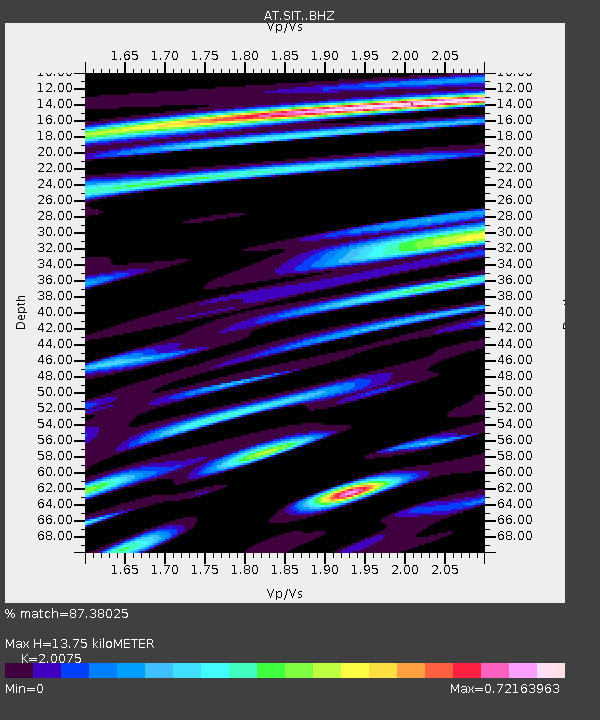
| Estimated Moho Depth: |
13.75 km |
| Estimated Crust Vp/Vs: |
2.01 |
| Assumed Crust Vp: |
6.472 km/s |
| Estimated Crust Vs: |
3.224 km/s |
| Estimated Crust Poisson's Ratio: |
0.33 |
|
| Radial Match: |
87.38025 % |
| Radial Bump: |
400 |
| Transverse Match: |
68.4906 % |
| Transverse Bump: |
400 |
| SOD ConfigId: |
34025071 |
| Insert Time: |
2024-04-19 11:10:35.025 +0000 |
| GWidth: |
2.5 |
| Max Bumps: |
400 |
| Tol: |
0.001 |
|

Signal To Noise
| Channel | StoN | STA | LTA |
| AT:SIT: :BHZ:20240405T11:13:22.939972Z | 22.199184 | 6.2358267E-6 | 2.809034E-7 |
| AT:SIT: :BHN:20240405T11:13:22.939972Z | 3.2263494 | 8.2215774E-7 | 2.5482603E-7 |
| AT:SIT: :BHE:20240405T11:13:22.939972Z | 10.358138 | 3.4446214E-6 | 3.325522E-7 |
| Arrivals |
| Ps | 2.2 SECOND |
| PpPs | 6.2 SECOND |
| PsPs/PpSs | 8.4 SECOND |


