You are here: Home > Network List > AV - Alaska Volcano Observatory Stations List
> Station AKHS Akutan Broiad Bright, Akutan Volcano, Alaska > Earthquake Result Viewer
AKHS Akutan Broiad Bright, Akutan Volcano, Alaska - Earthquake Result Viewer
| Earthquake location: |
Mariana Islands |
| Earthquake latitude/longitude: |
19.1/145.4 |
| Earthquake time(UTC): |
2024/04/05 (096) 11:03:16 GMT |
| Earthquake Depth: |
222 km |
| Earthquake Magnitude: |
6.8 mww |
| Earthquake Catalog/Contributor: |
NEIC PDE/us |
|
| Network: |
AV Alaska Volcano Observatory |
| Station: |
AKHS Akutan Broiad Bright, Akutan Volcano, Alaska |
| Lat/Lon: |
54.15 N/165.89 W |
| Elevation: |
150 m |
|
| Distance: |
50.9 deg |
| Az: |
34.698 deg |
| Baz: |
246.223 deg |
| Ray Param: |
0.066912755 |
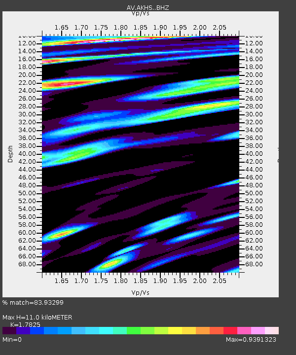
| Estimated Moho Depth: |
11.0 km |
| Estimated Crust Vp/Vs: |
1.78 |
| Assumed Crust Vp: |
5.989 km/s |
| Estimated Crust Vs: |
3.36 km/s |
| Estimated Crust Poisson's Ratio: |
0.27 |
|
| Radial Match: |
83.93299 % |
| Radial Bump: |
400 |
| Transverse Match: |
80.413826 % |
| Transverse Bump: |
400 |
| SOD ConfigId: |
34025071 |
| Insert Time: |
2024-04-19 11:12:02.863 +0000 |
| GWidth: |
2.5 |
| Max Bumps: |
400 |
| Tol: |
0.001 |
|

Signal To Noise
| Channel | StoN | STA | LTA |
| AV:AKHS: :BHZ:20240405T11:11:24.498993Z | 15.555636 | 1.3236512E-5 | 8.509142E-7 |
| AV:AKHS: :BHN:20240405T11:11:24.498993Z | 5.2169294 | 7.663469E-6 | 1.4689616E-6 |
| AV:AKHS: :BHE:20240405T11:11:24.498993Z | 10.872069 | 8.909277E-6 | 8.194648E-7 |
| Arrivals |
| Ps | 1.5 SECOND |
| PpPs | 4.9 SECOND |
| PsPs/PpSs | 6.4 SECOND |


