You are here: Home > Network List > AV - Alaska Volcano Observatory Stations List
> Station AKS Akutan Strait, Akutan Volcano, Alaska > Earthquake Result Viewer
AKS Akutan Strait, Akutan Volcano, Alaska - Earthquake Result Viewer
| Earthquake location: |
Mariana Islands |
| Earthquake latitude/longitude: |
19.1/145.4 |
| Earthquake time(UTC): |
2024/04/05 (096) 11:03:16 GMT |
| Earthquake Depth: |
222 km |
| Earthquake Magnitude: |
6.8 mww |
| Earthquake Catalog/Contributor: |
NEIC PDE/us |
|
| Network: |
AV Alaska Volcano Observatory |
| Station: |
AKS Akutan Strait, Akutan Volcano, Alaska |
| Lat/Lon: |
54.11 N/165.70 W |
| Elevation: |
213 m |
|
| Distance: |
51.0 deg |
| Az: |
34.807 deg |
| Baz: |
246.444 deg |
| Ray Param: |
0.06685756 |
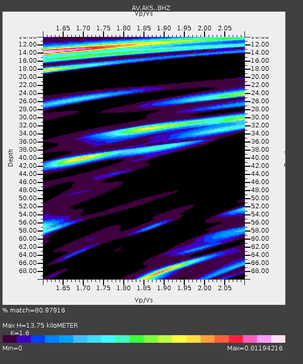
| Estimated Moho Depth: |
13.75 km |
| Estimated Crust Vp/Vs: |
1.60 |
| Assumed Crust Vp: |
5.989 km/s |
| Estimated Crust Vs: |
3.743 km/s |
| Estimated Crust Poisson's Ratio: |
0.18 |
|
| Radial Match: |
80.97916 % |
| Radial Bump: |
400 |
| Transverse Match: |
72.01553 % |
| Transverse Bump: |
400 |
| SOD ConfigId: |
34025071 |
| Insert Time: |
2024-04-19 11:12:06.114 +0000 |
| GWidth: |
2.5 |
| Max Bumps: |
400 |
| Tol: |
0.001 |
|

Signal To Noise
| Channel | StoN | STA | LTA |
| AV:AKS: :BHZ:20240405T11:11:25.139007Z | 6.023888 | 1.6387407E-5 | 2.7204035E-6 |
| AV:AKS: :BHN:20240405T11:11:25.139007Z | 2.4314947 | 3.7393543E-6 | 1.537883E-6 |
| AV:AKS: :BHE:20240405T11:11:25.139007Z | 2.4161775 | 4.4403264E-6 | 1.8377485E-6 |
| Arrivals |
| Ps | 1.5 SECOND |
| PpPs | 5.7 SECOND |
| PsPs/PpSs | 7.1 SECOND |


