You are here: Home > Network List > AV - Alaska Volcano Observatory Stations List
> Station GASW Southwest, Gareloi Volcano, Alaska > Earthquake Result Viewer
GASW Southwest, Gareloi Volcano, Alaska - Earthquake Result Viewer
| Earthquake location: |
Mariana Islands |
| Earthquake latitude/longitude: |
19.1/145.4 |
| Earthquake time(UTC): |
2024/04/05 (096) 11:03:16 GMT |
| Earthquake Depth: |
222 km |
| Earthquake Magnitude: |
6.8 mww |
| Earthquake Catalog/Contributor: |
NEIC PDE/us |
|
| Network: |
AV Alaska Volcano Observatory |
| Station: |
GASW Southwest, Gareloi Volcano, Alaska |
| Lat/Lon: |
51.78 N/178.86 W |
| Elevation: |
248 m |
|
| Distance: |
43.0 deg |
| Az: |
32.18 deg |
| Baz: |
234.154 deg |
| Ray Param: |
0.071979046 |
| Estimated Moho Depth: |
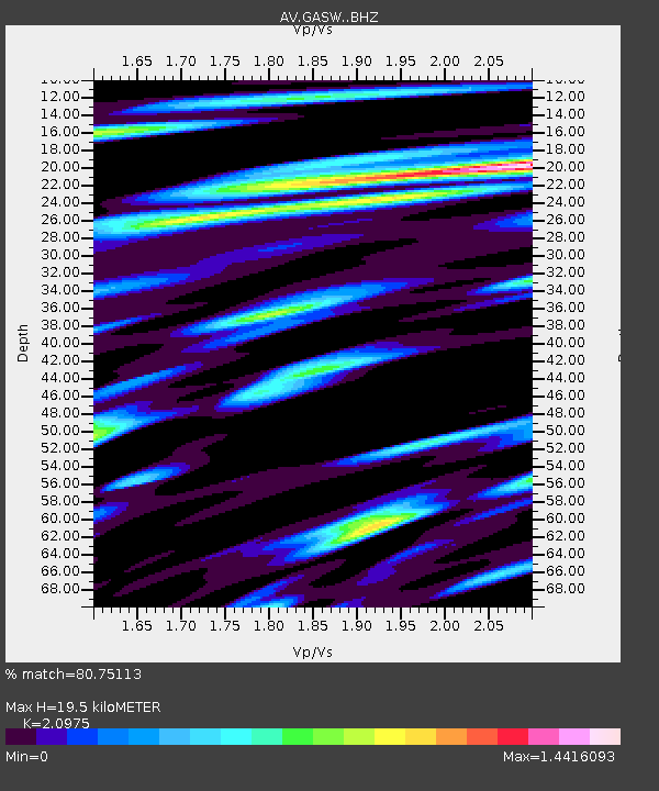
19.5 km |
| Estimated Crust Vp/Vs: |
2.10 |
| Assumed Crust Vp: |
6.048 km/s |
| Estimated Crust Vs: |
2.883 km/s |
| Estimated Crust Poisson's Ratio: |
0.35 |
|
| Radial Match: |
80.75113 % |
| Radial Bump: |
400 |
| Transverse Match: |
59.320297 % |
| Transverse Bump: |
400 |
| SOD ConfigId: |
34025071 |
| Insert Time: |
2024-04-19 11:13:09.215 +0000 |
| GWidth: |
2.5 |
| Max Bumps: |
400 |
| Tol: |
0.001 |
|

Signal To Noise
| Channel | StoN | STA | LTA |
| AV:GASW: :BHZ:20240405T11:10:23.039001Z | 10.18755 | 8.703658E-6 | 8.543426E-7 |
| AV:GASW: :BHN:20240405T11:10:23.039001Z | 3.0381107 | 6.4603E-6 | 2.1264202E-6 |
| AV:GASW: :BHE:20240405T11:10:23.039001Z | 2.6812248 | 5.271095E-6 | 1.9659278E-6 |
| Arrivals |
| Ps | 3.7 SECOND |
| PpPs | 9.5 SECOND |
| PsPs/PpSs | 13 SECOND |


