You are here: Home > Network List > AV - Alaska Volcano Observatory Stations List
> Station GSIG Igitkin Island, Great Sitkin Volcano, Alaska > Earthquake Result Viewer
GSIG Igitkin Island, Great Sitkin Volcano, Alaska - Earthquake Result Viewer
| Earthquake location: |
Mariana Islands |
| Earthquake latitude/longitude: |
19.1/145.4 |
| Earthquake time(UTC): |
2024/04/05 (096) 11:03:16 GMT |
| Earthquake Depth: |
222 km |
| Earthquake Magnitude: |
6.8 mww |
| Earthquake Catalog/Contributor: |
NEIC PDE/us |
|
| Network: |
AV Alaska Volcano Observatory |
| Station: |
GSIG Igitkin Island, Great Sitkin Volcano, Alaska |
| Lat/Lon: |
51.99 N/175.93 W |
| Elevation: |
407 m |
|
| Distance: |
44.6 deg |
| Az: |
33.409 deg |
| Baz: |
237.34 deg |
| Ray Param: |
0.070961826 |
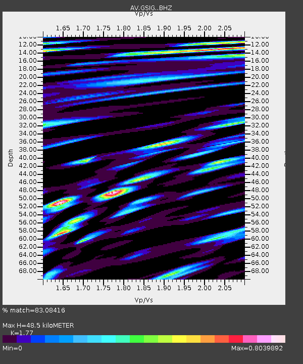
| Estimated Moho Depth: |
48.5 km |
| Estimated Crust Vp/Vs: |
1.77 |
| Assumed Crust Vp: |
3.943 km/s |
| Estimated Crust Vs: |
2.228 km/s |
| Estimated Crust Poisson's Ratio: |
0.27 |
|
| Radial Match: |
83.08416 % |
| Radial Bump: |
400 |
| Transverse Match: |
62.76712 % |
| Transverse Bump: |
400 |
| SOD ConfigId: |
34025071 |
| Insert Time: |
2024-04-19 11:13:12.539 +0000 |
| GWidth: |
2.5 |
| Max Bumps: |
400 |
| Tol: |
0.001 |
|
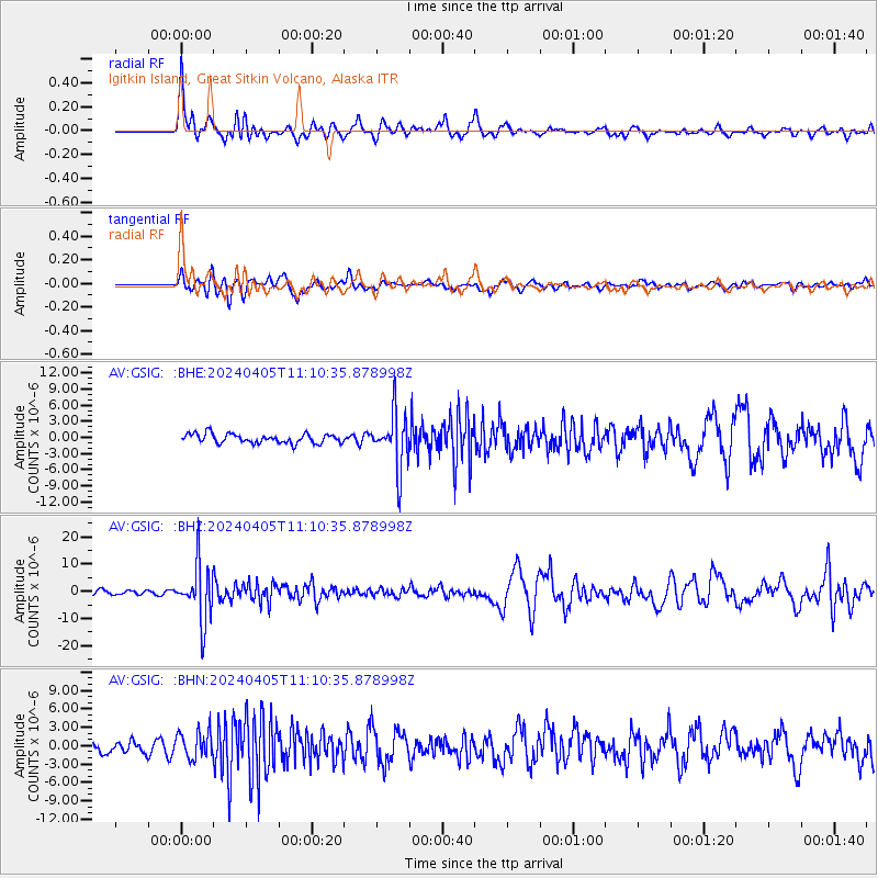
Signal To Noise
| Channel | StoN | STA | LTA |
| AV:GSIG: :BHZ:20240405T11:10:35.878998Z | 12.434591 | 1.0354785E-5 | 8.3274034E-7 |
| AV:GSIG: :BHN:20240405T11:10:35.878998Z | 1.8272711 | 2.2163242E-6 | 1.2129149E-6 |
| AV:GSIG: :BHE:20240405T11:10:35.878998Z | 5.9153194 | 5.116232E-6 | 8.649122E-7 |
| Arrivals |
| Ps | 9.7 SECOND |
| PpPs | 33 SECOND |
| PsPs/PpSs | 43 SECOND |


