You are here: Home > Network List > UW - Pacific Northwest Regional Seismic Network Stations List
> Station MRBL Marblemount, WA, USA > Earthquake Result Viewer
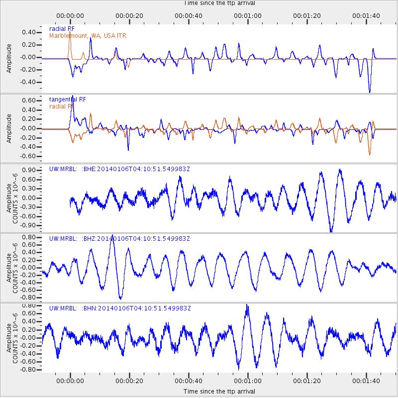
MRBL Marblemount, WA, USA - Earthquake Result Viewer
*The percent match for this event was below the threshold and hence no stack was calculated.
| Earthquake location: |
Near Coast Of Northern Chile |
| Earthquake latitude/longitude: |
-20.7/-70.6 |
| Earthquake time(UTC): |
2014/01/06 (006) 03:59:02 GMT |
| Earthquake Depth: |
27 km |
| Earthquake Magnitude: |
5.2 MW |
| Earthquake Catalog/Contributor: |
ISC/ISC |
|
| Network: |
UW Pacific Northwest Regional Seismic Network |
| Station: |
MRBL Marblemount, WA, USA |
| Lat/Lon: |
48.52 N/121.48 W |
| Elevation: |
75 m |
|
| Distance: |
82.5 deg |
| Az: |
328.667 deg |
| Baz: |
132.932 deg |
| Ray Param: |
$rayparam |
*The percent match for this event was below the threshold and hence was not used in the summary stack. |
|
| Radial Match: |
65.06333 % |
| Radial Bump: |
400 |
| Transverse Match: |
75.18991 % |
| Transverse Bump: |
400 |
| SOD ConfigId: |
3390531 |
| Insert Time: |
2019-04-09 21:45:08.942 +0000 |
| GWidth: |
2.5 |
| Max Bumps: |
400 |
| Tol: |
0.001 |
|
Signal To Noise
| Channel | StoN | STA | LTA |
| UW:MRBL: :BHZ:20140106T04:10:51.549983Z | 0.66298527 | 2.2744334E-7 | 3.430594E-7 |
| UW:MRBL: :BHN:20140106T04:10:51.549983Z | 0.4185773 | 9.4744E-8 | 2.2634768E-7 |
| UW:MRBL: :BHE:20140106T04:10:51.549983Z | 1.6959455 | 3.0796224E-7 | 1.8158735E-7 |
| Arrivals |
| Ps | |
| PpPs | |
| PsPs/PpSs | |


