You are here: Home > Network List > AV - Alaska Volcano Observatory Stations List
> Station ISNN Isanotski North, Isanotski, Alaska > Earthquake Result Viewer
ISNN Isanotski North, Isanotski, Alaska - Earthquake Result Viewer
| Earthquake location: |
Mariana Islands |
| Earthquake latitude/longitude: |
19.1/145.4 |
| Earthquake time(UTC): |
2024/04/05 (096) 11:03:16 GMT |
| Earthquake Depth: |
222 km |
| Earthquake Magnitude: |
6.8 mww |
| Earthquake Catalog/Contributor: |
NEIC PDE/us |
|
| Network: |
AV Alaska Volcano Observatory |
| Station: |
ISNN Isanotski North, Isanotski, Alaska |
| Lat/Lon: |
54.83 N/163.78 W |
| Elevation: |
466 m |
|
| Distance: |
52.3 deg |
| Az: |
34.512 deg |
| Baz: |
247.819 deg |
| Ray Param: |
0.06602236 |
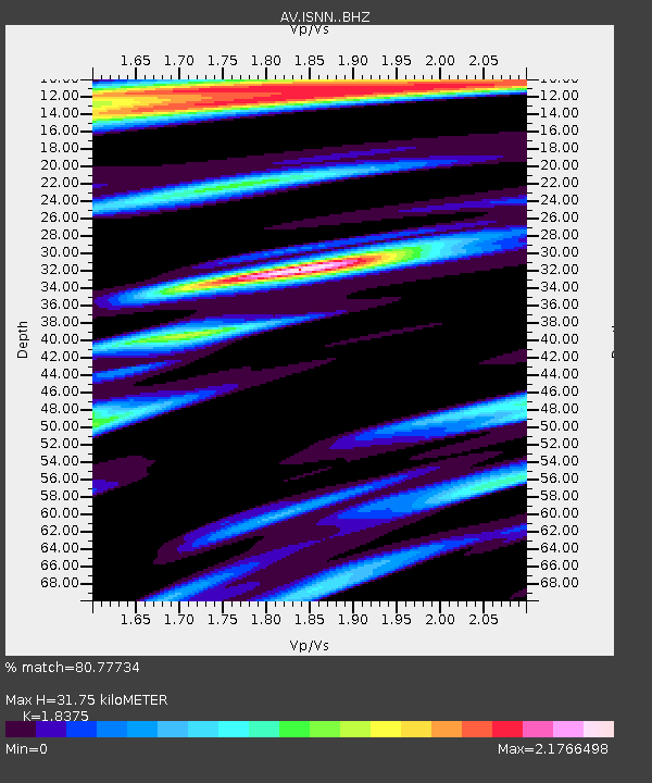
| Estimated Moho Depth: |
31.75 km |
| Estimated Crust Vp/Vs: |
1.84 |
| Assumed Crust Vp: |
5.989 km/s |
| Estimated Crust Vs: |
3.259 km/s |
| Estimated Crust Poisson's Ratio: |
0.29 |
|
| Radial Match: |
80.77734 % |
| Radial Bump: |
400 |
| Transverse Match: |
67.432236 % |
| Transverse Bump: |
400 |
| SOD ConfigId: |
34025071 |
| Insert Time: |
2024-04-19 11:13:29.776 +0000 |
| GWidth: |
2.5 |
| Max Bumps: |
400 |
| Tol: |
0.001 |
|

Signal To Noise
| Channel | StoN | STA | LTA |
| AV:ISNN: :BHZ:20240405T11:11:34.799988Z | 8.377479 | 1.8685092E-5 | 2.2303957E-6 |
| AV:ISNN: :BHN:20240405T11:11:34.799988Z | 1.303141 | 2.828588E-6 | 2.1705926E-6 |
| AV:ISNN: :BHE:20240405T11:11:34.799988Z | 5.02644 | 7.7329005E-6 | 1.5384447E-6 |
| Arrivals |
| Ps | 4.6 SECOND |
| PpPs | 14 SECOND |
| PsPs/PpSs | 19 SECOND |


