You are here: Home > Network List > AV - Alaska Volcano Observatory Stations List
> Station KAHG Katmai Hook Glacier, Alaska > Earthquake Result Viewer
KAHG Katmai Hook Glacier, Alaska - Earthquake Result Viewer
| Earthquake location: |
Mariana Islands |
| Earthquake latitude/longitude: |
19.1/145.4 |
| Earthquake time(UTC): |
2024/04/05 (096) 11:03:16 GMT |
| Earthquake Depth: |
222 km |
| Earthquake Magnitude: |
6.8 mww |
| Earthquake Catalog/Contributor: |
NEIC PDE/us |
|
| Network: |
AV Alaska Volcano Observatory |
| Station: |
KAHG Katmai Hook Glacier, Alaska |
| Lat/Lon: |
58.49 N/154.55 W |
| Elevation: |
923 m |
|
| Distance: |
58.4 deg |
| Az: |
32.315 deg |
| Baz: |
254.274 deg |
| Ray Param: |
0.06216198 |
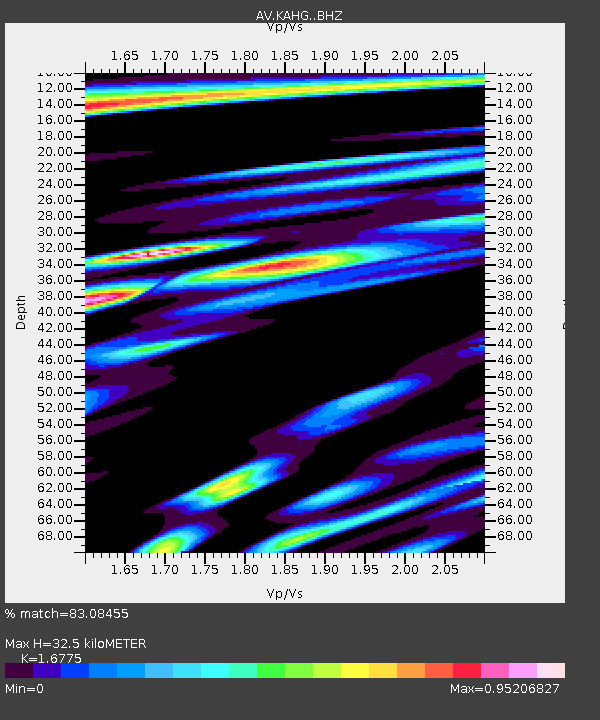
| Estimated Moho Depth: |
32.5 km |
| Estimated Crust Vp/Vs: |
1.68 |
| Assumed Crust Vp: |
6.438 km/s |
| Estimated Crust Vs: |
3.838 km/s |
| Estimated Crust Poisson's Ratio: |
0.22 |
|
| Radial Match: |
83.08455 % |
| Radial Bump: |
400 |
| Transverse Match: |
83.175735 % |
| Transverse Bump: |
400 |
| SOD ConfigId: |
34025071 |
| Insert Time: |
2024-04-19 11:13:36.221 +0000 |
| GWidth: |
2.5 |
| Max Bumps: |
400 |
| Tol: |
0.001 |
|

Signal To Noise
| Channel | StoN | STA | LTA |
| AV:KAHG: :BHZ:20240405T11:12:17.50003Z | 36.802578 | 1.1997815E-5 | 3.2600474E-7 |
| AV:KAHG: :BHN:20240405T11:12:17.50003Z | 6.491554 | 2.7302083E-6 | 4.2057854E-7 |
| AV:KAHG: :BHE:20240405T11:12:17.50003Z | 18.94088 | 5.8001615E-6 | 3.0622448E-7 |
| Arrivals |
| Ps | 3.6 SECOND |
| PpPs | 13 SECOND |
| PsPs/PpSs | 16 SECOND |


