You are here: Home > Network List > AV - Alaska Volcano Observatory Stations List
> Station KAPH Katmai Pasha, Alaska > Earthquake Result Viewer
KAPH Katmai Pasha, Alaska - Earthquake Result Viewer
| Earthquake location: |
Mariana Islands |
| Earthquake latitude/longitude: |
19.1/145.4 |
| Earthquake time(UTC): |
2024/04/05 (096) 11:03:16 GMT |
| Earthquake Depth: |
222 km |
| Earthquake Magnitude: |
6.8 mww |
| Earthquake Catalog/Contributor: |
NEIC PDE/us |
|
| Network: |
AV Alaska Volcano Observatory |
| Station: |
KAPH Katmai Pasha, Alaska |
| Lat/Lon: |
58.60 N/154.35 W |
| Elevation: |
907 m |
|
| Distance: |
58.5 deg |
| Az: |
32.232 deg |
| Baz: |
254.4 deg |
| Ray Param: |
0.06207597 |
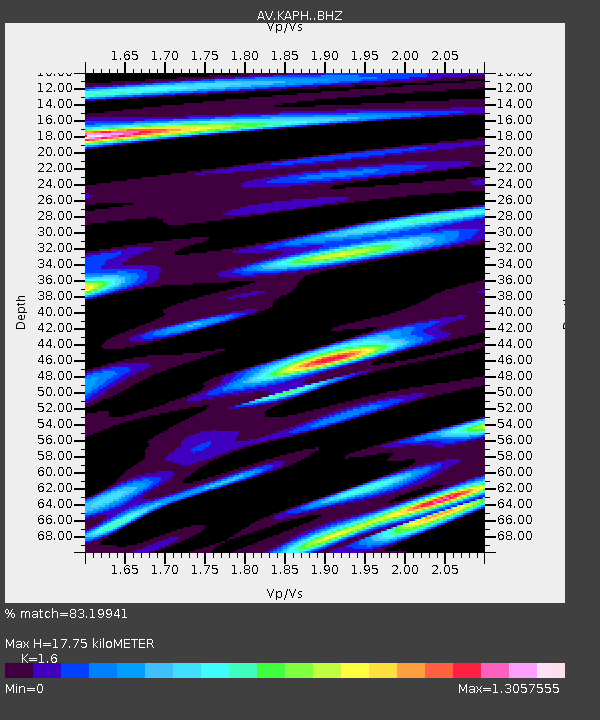
| Estimated Moho Depth: |
17.75 km |
| Estimated Crust Vp/Vs: |
1.60 |
| Assumed Crust Vp: |
6.438 km/s |
| Estimated Crust Vs: |
4.024 km/s |
| Estimated Crust Poisson's Ratio: |
0.18 |
|
| Radial Match: |
83.19941 % |
| Radial Bump: |
400 |
| Transverse Match: |
80.551926 % |
| Transverse Bump: |
400 |
| SOD ConfigId: |
34025071 |
| Insert Time: |
2024-04-19 11:13:39.574 +0000 |
| GWidth: |
2.5 |
| Max Bumps: |
400 |
| Tol: |
0.001 |
|

Signal To Noise
| Channel | StoN | STA | LTA |
| AV:KAPH: :BHZ:20240405T11:12:18.378998Z | 24.827122 | 1.18357875E-5 | 4.7672813E-7 |
| AV:KAPH: :BHN:20240405T11:12:18.378998Z | 10.779135 | 3.9252477E-6 | 3.6415236E-7 |
| AV:KAPH: :BHE:20240405T11:12:18.378998Z | 8.183505 | 3.2427943E-6 | 3.9625982E-7 |
| Arrivals |
| Ps | 1.7 SECOND |
| PpPs | 6.8 SECOND |
| PsPs/PpSs | 8.5 SECOND |


