You are here: Home > Network List > AV - Alaska Volcano Observatory Stations List
> Station PLBL Mt. Peulik Volcano, Alaska > Earthquake Result Viewer
PLBL Mt. Peulik Volcano, Alaska - Earthquake Result Viewer
| Earthquake location: |
Mariana Islands |
| Earthquake latitude/longitude: |
19.1/145.4 |
| Earthquake time(UTC): |
2024/04/05 (096) 11:03:16 GMT |
| Earthquake Depth: |
222 km |
| Earthquake Magnitude: |
6.8 mww |
| Earthquake Catalog/Contributor: |
NEIC PDE/us |
|
| Network: |
AV Alaska Volcano Observatory |
| Station: |
PLBL Mt. Peulik Volcano, Alaska |
| Lat/Lon: |
57.70 N/156.82 W |
| Elevation: |
461 m |
|
| Distance: |
57.0 deg |
| Az: |
32.812 deg |
| Baz: |
252.614 deg |
| Ray Param: |
0.063053556 |
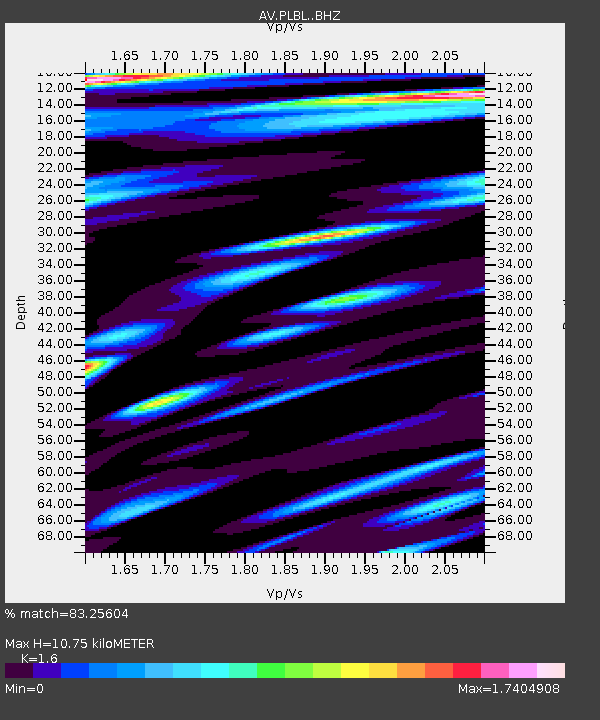
| Estimated Moho Depth: |
10.75 km |
| Estimated Crust Vp/Vs: |
1.60 |
| Assumed Crust Vp: |
6.1 km/s |
| Estimated Crust Vs: |
3.812 km/s |
| Estimated Crust Poisson's Ratio: |
0.18 |
|
| Radial Match: |
83.25604 % |
| Radial Bump: |
400 |
| Transverse Match: |
76.74037 % |
| Transverse Bump: |
400 |
| SOD ConfigId: |
34025071 |
| Insert Time: |
2024-04-19 11:14:46.395 +0000 |
| GWidth: |
2.5 |
| Max Bumps: |
400 |
| Tol: |
0.001 |
|

Signal To Noise
| Channel | StoN | STA | LTA |
| AV:PLBL: :BHZ:20240405T11:12:07.878998Z | 42.188744 | 1.5163863E-5 | 3.5942912E-7 |
| AV:PLBL: :BHN:20240405T11:12:07.878998Z | 9.9572735 | 5.7145E-6 | 5.7390207E-7 |
| AV:PLBL: :BHE:20240405T11:12:07.878998Z | 19.408154 | 1.1396264E-5 | 5.8718945E-7 |
| Arrivals |
| Ps | 1.1 SECOND |
| PpPs | 4.4 SECOND |
| PsPs/PpSs | 5.5 SECOND |


