You are here: Home > Network List > AV - Alaska Volcano Observatory Stations List
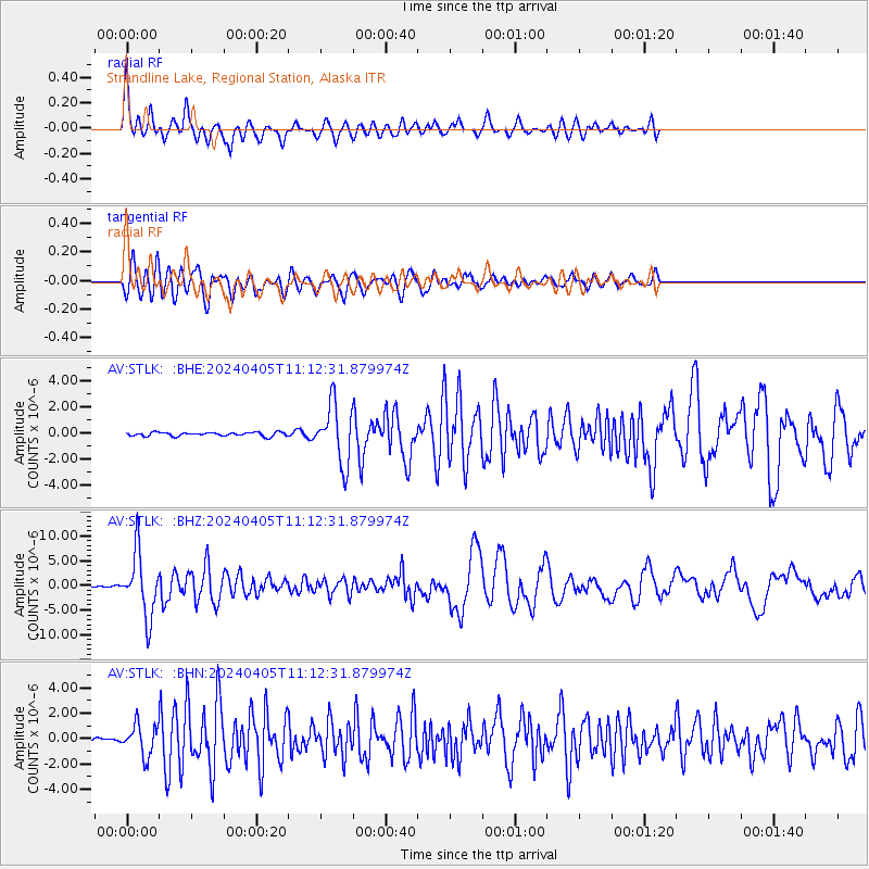
> Station STLK Strandline Lake, Regional Station, Alaska > Earthquake Result Viewer
STLK Strandline Lake, Regional Station, Alaska - Earthquake Result Viewer
| Earthquake location: |
Mariana Islands |
| Earthquake latitude/longitude: |
19.1/145.4 |
| Earthquake time(UTC): |
2024/04/05 (096) 11:03:16 GMT |
| Earthquake Depth: |
222 km |
| Earthquake Magnitude: |
6.8 mww |
| Earthquake Catalog/Contributor: |
NEIC PDE/us |
|
| Network: |
AV Alaska Volcano Observatory |
| Station: |
STLK Strandline Lake, Regional Station, Alaska |
| Lat/Lon: |
61.50 N/151.83 W |
| Elevation: |
945 m |
|
| Distance: |
60.5 deg |
| Az: |
29.356 deg |
| Baz: |
255.115 deg |
| Ray Param: |
0.060791537 |
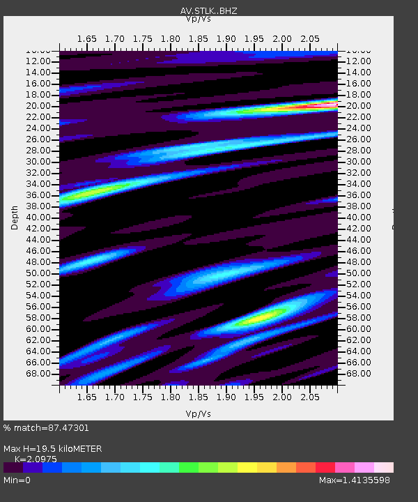
| Estimated Moho Depth: |
19.5 km |
| Estimated Crust Vp/Vs: |
2.10 |
| Assumed Crust Vp: |
6.302 km/s |
| Estimated Crust Vs: |
3.004 km/s |
| Estimated Crust Poisson's Ratio: |
0.35 |
|
| Radial Match: |
87.47301 % |
| Radial Bump: |
400 |
| Transverse Match: |
70.48627 % |
| Transverse Bump: |
400 |
| SOD ConfigId: |
34025071 |
| Insert Time: |
2024-04-19 11:15:19.394 +0000 |
| GWidth: |
2.5 |
| Max Bumps: |
400 |
| Tol: |
0.001 |
|
Signal To Noise
| Channel | StoN | STA | LTA |
| AV:STLK: :BHZ:20240405T11:12:31.879974Z | 37.28126 | 6.293031E-6 | 1.6879876E-7 |
| AV:STLK: :BHN:20240405T11:12:31.879974Z | 3.978719 | 1.1949459E-6 | 3.003343E-7 |
| AV:STLK: :BHE:20240405T11:12:31.879974Z | 15.917892 | 2.2566467E-6 | 1.4176793E-7 |
| Arrivals |
| Ps | 3.5 SECOND |
| PpPs | 9.2 SECOND |
| PsPs/PpSs | 13 SECOND |


