You are here: Home > Network List > AV - Alaska Volcano Observatory Stations List
> Station VNKR Kametolook River, Mount Veniaminof, Alaska > Earthquake Result Viewer
VNKR Kametolook River, Mount Veniaminof, Alaska - Earthquake Result Viewer
| Earthquake location: |
Mariana Islands |
| Earthquake latitude/longitude: |
19.1/145.4 |
| Earthquake time(UTC): |
2024/04/05 (096) 11:03:16 GMT |
| Earthquake Depth: |
222 km |
| Earthquake Magnitude: |
6.8 mww |
| Earthquake Catalog/Contributor: |
NEIC PDE/us |
|
| Network: |
AV Alaska Volcano Observatory |
| Station: |
VNKR Kametolook River, Mount Veniaminof, Alaska |
| Lat/Lon: |
56.03 N/159.37 W |
| Elevation: |
620 m |
|
| Distance: |
55.1 deg |
| Az: |
34.206 deg |
| Baz: |
251.262 deg |
| Ray Param: |
0.06424006 |
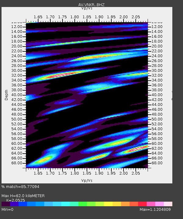
| Estimated Moho Depth: |
62.0 km |
| Estimated Crust Vp/Vs: |
2.05 |
| Assumed Crust Vp: |
6.134 km/s |
| Estimated Crust Vs: |
2.988 km/s |
| Estimated Crust Poisson's Ratio: |
0.34 |
|
| Radial Match: |
85.77094 % |
| Radial Bump: |
400 |
| Transverse Match: |
81.76215 % |
| Transverse Bump: |
400 |
| SOD ConfigId: |
34025071 |
| Insert Time: |
2024-04-19 11:15:33.633 +0000 |
| GWidth: |
2.5 |
| Max Bumps: |
400 |
| Tol: |
0.001 |
|

Signal To Noise
| Channel | StoN | STA | LTA |
| AV:VNKR: :BHZ:20240405T11:11:54.83902Z | 35.460094 | 2.1086596E-5 | 5.946571E-7 |
| AV:VNKR: :BHN:20240405T11:11:54.83902Z | 4.1055017 | 4.927521E-6 | 1.2002239E-6 |
| AV:VNKR: :BHE:20240405T11:11:54.83902Z | 12.042321 | 8.078836E-6 | 6.7087035E-7 |
| Arrivals |
| Ps | 11 SECOND |
| PpPs | 30 SECOND |
| PsPs/PpSs | 41 SECOND |


