You are here: Home > Network List > AV - Alaska Volcano Observatory Stations List
> Station VNSW Southwest, Mount Veniaminof, Alaska > Earthquake Result Viewer
VNSW Southwest, Mount Veniaminof, Alaska - Earthquake Result Viewer

| Earthquake location: |
Mariana Islands |
| Earthquake latitude/longitude: |
19.1/145.4 |
| Earthquake time(UTC): |
2024/04/05 (096) 11:03:16 GMT |
| Earthquake Depth: |
222 km |
| Earthquake Magnitude: |
6.8 mww |
| Earthquake Catalog/Contributor: |
NEIC PDE/us |
|
| Network: |
AV Alaska Volcano Observatory |
| Station: |
VNSW Southwest, Mount Veniaminof, Alaska |
| Lat/Lon: |
56.07 N/159.56 W |
| Elevation: |
697 m |
|
| Distance: |
55.0 deg |
| Az: |
34.116 deg |
| Baz: |
251.053 deg |
| Ray Param: |
0.06429828 |
| Estimated Moho Depth: |
40.25 km |
| Estimated Crust Vp/Vs: |
1.65 |
| Assumed Crust Vp: |
6.134 km/s |
| Estimated Crust Vs: |
3.706 km/s |
| Estimated Crust Poisson's Ratio: |
0.21 |
|
| Radial Match: |
82.47456 % |
| Radial Bump: |
400 |
| Transverse Match: |
79.503685 % |
| Transverse Bump: |
400 |
| SOD ConfigId: |
34025071 |
| Insert Time: |
2024-04-19 11:15:38.699 +0000 |
| GWidth: |
2.5 |
| Max Bumps: |
400 |
| Tol: |
0.001 |
|
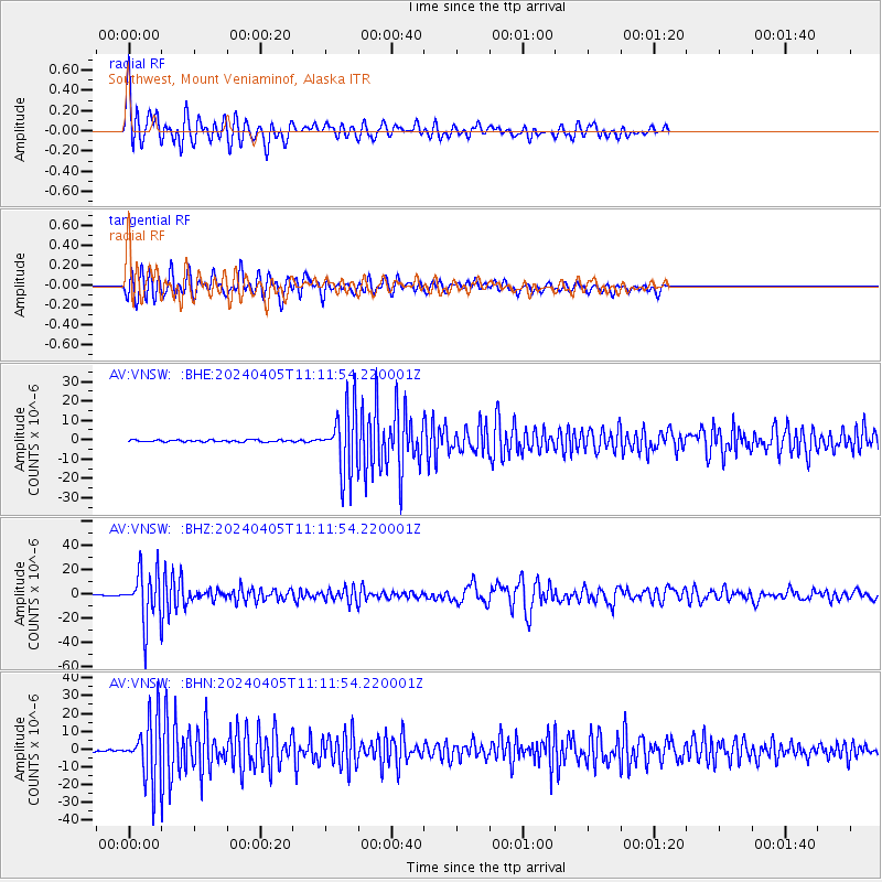
Signal To Noise
| Channel | StoN | STA | LTA |
| AV:VNSW: :BHZ:20240405T11:11:54.220001Z | 54.712692 | 2.0921749E-5 | 3.8239295E-7 |
| AV:VNSW: :BHN:20240405T11:11:54.220001Z | 31.132345 | 1.7170569E-5 | 5.5153464E-7 |
| AV:VNSW: :BHE:20240405T11:11:54.220001Z | 33.561687 | 1.6331773E-5 | 4.8661957E-7 |
| Arrivals |
| Ps | 4.5 SECOND |
| PpPs | 17 SECOND |
| PsPs/PpSs | 21 SECOND |


