You are here: Home > Network List > C0 - Colorado Geological Survey Seismic Network Stations List
> Station LAMA Lamar Colorado > Earthquake Result Viewer
LAMA Lamar Colorado - Earthquake Result Viewer
| Earthquake location: |
Mariana Islands |
| Earthquake latitude/longitude: |
19.1/145.4 |
| Earthquake time(UTC): |
2024/04/05 (096) 11:03:16 GMT |
| Earthquake Depth: |
222 km |
| Earthquake Magnitude: |
6.8 mww |
| Earthquake Catalog/Contributor: |
NEIC PDE/us |
|
| Network: |
C0 Colorado Geological Survey Seismic Network |
| Station: |
LAMA Lamar Colorado |
| Lat/Lon: |
38.27 N/102.65 W |
| Elevation: |
1182 m |
|
| Distance: |
94.5 deg |
| Az: |
47.068 deg |
| Baz: |
298.405 deg |
| Ray Param: |
0.040872023 |
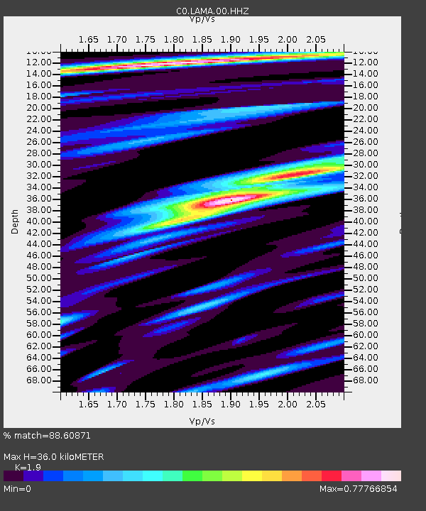
| Estimated Moho Depth: |
36.0 km |
| Estimated Crust Vp/Vs: |
1.90 |
| Assumed Crust Vp: |
6.242 km/s |
| Estimated Crust Vs: |
3.285 km/s |
| Estimated Crust Poisson's Ratio: |
0.31 |
|
| Radial Match: |
88.60871 % |
| Radial Bump: |
371 |
| Transverse Match: |
71.75588 % |
| Transverse Bump: |
400 |
| SOD ConfigId: |
34025071 |
| Insert Time: |
2024-04-19 11:16:58.109 +0000 |
| GWidth: |
2.5 |
| Max Bumps: |
400 |
| Tol: |
0.001 |
|

Signal To Noise
| Channel | StoN | STA | LTA |
| C0:LAMA:00:HHZ:20240405T11:15:39.699981Z | 45.51896 | 6.450138E-6 | 1.4170222E-7 |
| C0:LAMA:00:HHN:20240405T11:15:39.699981Z | 2.3099432 | 7.5532057E-7 | 3.2698662E-7 |
| C0:LAMA:00:HHE:20240405T11:15:39.699981Z | 10.896747 | 1.9087677E-6 | 1.7516858E-7 |
| Arrivals |
| Ps | 5.3 SECOND |
| PpPs | 16 SECOND |
| PsPs/PpSs | 22 SECOND |


