You are here: Home > Network List > CC - Cascade Chain Volcano Monitoring Stations List
> Station PR02 Puyallup River 02 > Earthquake Result Viewer
PR02 Puyallup River 02 - Earthquake Result Viewer
| Earthquake location: |
Mariana Islands |
| Earthquake latitude/longitude: |
19.1/145.4 |
| Earthquake time(UTC): |
2024/04/05 (096) 11:03:16 GMT |
| Earthquake Depth: |
222 km |
| Earthquake Magnitude: |
6.8 mww |
| Earthquake Catalog/Contributor: |
NEIC PDE/us |
|
| Network: |
CC Cascade Chain Volcano Monitoring |
| Station: |
PR02 Puyallup River 02 |
| Lat/Lon: |
46.92 N/122.05 W |
| Elevation: |
461 m |
|
| Distance: |
78.0 deg |
| Az: |
44.435 deg |
| Baz: |
285.039 deg |
| Ray Param: |
0.04936859 |
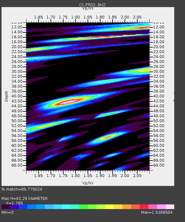
| Estimated Moho Depth: |
42.25 km |
| Estimated Crust Vp/Vs: |
1.76 |
| Assumed Crust Vp: |
6.566 km/s |
| Estimated Crust Vs: |
3.72 km/s |
| Estimated Crust Poisson's Ratio: |
0.26 |
|
| Radial Match: |
85.775024 % |
| Radial Bump: |
400 |
| Transverse Match: |
80.07599 % |
| Transverse Bump: |
400 |
| SOD ConfigId: |
34025071 |
| Insert Time: |
2024-04-19 11:18:05.545 +0000 |
| GWidth: |
2.5 |
| Max Bumps: |
400 |
| Tol: |
0.001 |
|

Signal To Noise
| Channel | StoN | STA | LTA |
| CC:PR02: :BHZ:20240405T11:14:19.019989Z | 37.962765 | 1.331092E-5 | 3.5063093E-7 |
| CC:PR02: :BHN:20240405T11:14:19.019989Z | 5.936368 | 2.3875125E-6 | 4.0218407E-7 |
| CC:PR02: :BHE:20240405T11:14:19.019989Z | 11.870935 | 5.658428E-6 | 4.7666236E-7 |
| Arrivals |
| Ps | 5.1 SECOND |
| PpPs | 17 SECOND |
| PsPs/PpSs | 22 SECOND |


