You are here: Home > Network List > CC - Cascade Chain Volcano Monitoring Stations List
> Station UNFR Upper North Fork Repeater > Earthquake Result Viewer
UNFR Upper North Fork Repeater - Earthquake Result Viewer
| Earthquake location: |
Mariana Islands |
| Earthquake latitude/longitude: |
19.1/145.4 |
| Earthquake time(UTC): |
2024/04/05 (096) 11:03:16 GMT |
| Earthquake Depth: |
222 km |
| Earthquake Magnitude: |
6.8 mww |
| Earthquake Catalog/Contributor: |
NEIC PDE/us |
|
| Network: |
CC Cascade Chain Volcano Monitoring |
| Station: |
UNFR Upper North Fork Repeater |
| Lat/Lon: |
46.27 N/122.29 W |
| Elevation: |
884 m |
|
| Distance: |
78.0 deg |
| Az: |
45.117 deg |
| Baz: |
285.004 deg |
| Ray Param: |
0.04936495 |
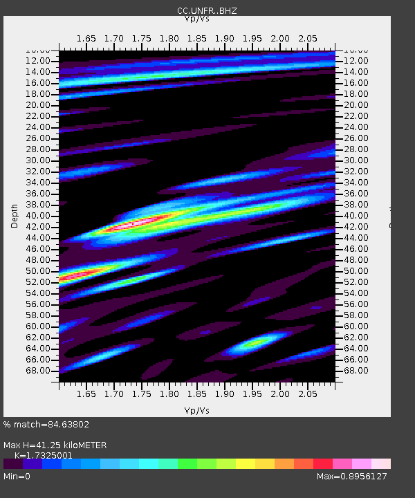
| Estimated Moho Depth: |
41.25 km |
| Estimated Crust Vp/Vs: |
1.73 |
| Assumed Crust Vp: |
6.566 km/s |
| Estimated Crust Vs: |
3.79 km/s |
| Estimated Crust Poisson's Ratio: |
0.25 |
|
| Radial Match: |
84.63802 % |
| Radial Bump: |
400 |
| Transverse Match: |
77.850815 % |
| Transverse Bump: |
400 |
| SOD ConfigId: |
34025071 |
| Insert Time: |
2024-04-19 11:18:38.086 +0000 |
| GWidth: |
2.5 |
| Max Bumps: |
400 |
| Tol: |
0.001 |
|

Signal To Noise
| Channel | StoN | STA | LTA |
| CC:UNFR: :BHZ:20240405T11:14:19.040008Z | 39.835846 | 1.3609115E-5 | 3.4162986E-7 |
| CC:UNFR: :BHN:20240405T11:14:19.040008Z | 8.463397 | 2.1903916E-6 | 2.588076E-7 |
| CC:UNFR: :BHE:20240405T11:14:19.040008Z | 15.501702 | 5.8504625E-6 | 3.7740773E-7 |
| Arrivals |
| Ps | 4.7 SECOND |
| PpPs | 17 SECOND |
| PsPs/PpSs | 21 SECOND |


