You are here: Home > Network List > CC - Cascade Chain Volcano Monitoring Stations List
> Station KAVK Kavik - Ashford Fire Station > Earthquake Result Viewer
KAVK Kavik - Ashford Fire Station - Earthquake Result Viewer
| Earthquake location: |
Mariana Islands |
| Earthquake latitude/longitude: |
19.1/145.4 |
| Earthquake time(UTC): |
2024/04/05 (096) 11:03:16 GMT |
| Earthquake Depth: |
222 km |
| Earthquake Magnitude: |
6.8 mww |
| Earthquake Catalog/Contributor: |
NEIC PDE/us |
|
| Network: |
CC Cascade Chain Volcano Monitoring |
| Station: |
KAVK Kavik - Ashford Fire Station |
| Lat/Lon: |
46.76 N/122.04 W |
| Elevation: |
532 m |
|
| Distance: |
78.0 deg |
| Az: |
44.589 deg |
| Baz: |
285.078 deg |
| Ray Param: |
0.04933615 |
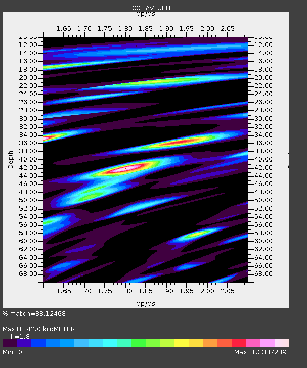
| Estimated Moho Depth: |
42.0 km |
| Estimated Crust Vp/Vs: |
1.80 |
| Assumed Crust Vp: |
6.566 km/s |
| Estimated Crust Vs: |
3.648 km/s |
| Estimated Crust Poisson's Ratio: |
0.28 |
|
| Radial Match: |
88.12468 % |
| Radial Bump: |
400 |
| Transverse Match: |
81.78587 % |
| Transverse Bump: |
400 |
| SOD ConfigId: |
34025071 |
| Insert Time: |
2024-04-19 11:18:51.164 +0000 |
| GWidth: |
2.5 |
| Max Bumps: |
400 |
| Tol: |
0.001 |
|

Signal To Noise
| Channel | StoN | STA | LTA |
| CC:KAVK: :BHZ:20240405T11:14:19.279999Z | 61.142067 | 1.650063E-5 | 2.6987357E-7 |
| CC:KAVK: :BHN:20240405T11:14:19.279999Z | 5.856789 | 2.5592306E-6 | 4.3696818E-7 |
| CC:KAVK: :BHE:20240405T11:14:19.279999Z | 21.58758 | 6.2798313E-6 | 2.909002E-7 |
| Arrivals |
| Ps | 5.3 SECOND |
| PpPs | 17 SECOND |
| PsPs/PpSs | 23 SECOND |


