You are here: Home > Network List > TA - USArray Transportable Network (new EarthScope stations) Stations List
> Station 429A Davenport Ranch, Sheffield, TX, USA > Earthquake Result Viewer
429A Davenport Ranch, Sheffield, TX, USA - Earthquake Result Viewer

| Earthquake location: |
Tonga Islands |
| Earthquake latitude/longitude: |
-20.5/-173.9 |
| Earthquake time(UTC): |
2010/10/16 (289) 13:27:45 GMT |
| Earthquake Depth: |
7.4 km |
| Earthquake Magnitude: |
5.7 MB, 5.7 MS, 5.6 MW, 5.6 MW |
| Earthquake Catalog/Contributor: |
WHDF/NEIC |
|
| Network: |
TA USArray Transportable Network (new EarthScope stations) |
| Station: |
429A Davenport Ranch, Sheffield, TX, USA |
| Lat/Lon: |
30.62 N/101.89 W |
| Elevation: |
804 m |
|
| Distance: |
85.8 deg |
| Az: |
55.3 deg |
| Baz: |
243.42 deg |
| Ray Param: |
0.0445134 |
| Estimated Moho Depth: |
36.75 km |
| Estimated Crust Vp/Vs: |
1.97 |
| Assumed Crust Vp: |
6.38 km/s |
| Estimated Crust Vs: |
3.243 km/s |
| Estimated Crust Poisson's Ratio: |
0.33 |
|
| Radial Match: |
81.88446 % |
| Radial Bump: |
363 |
| Transverse Match: |
67.15234 % |
| Transverse Bump: |
377 |
| SOD ConfigId: |
339645 |
| Insert Time: |
2011-02-17 07:47:58.305 +0000 |
| GWidth: |
2.5 |
| Max Bumps: |
400 |
| Tol: |
0.001 |
|
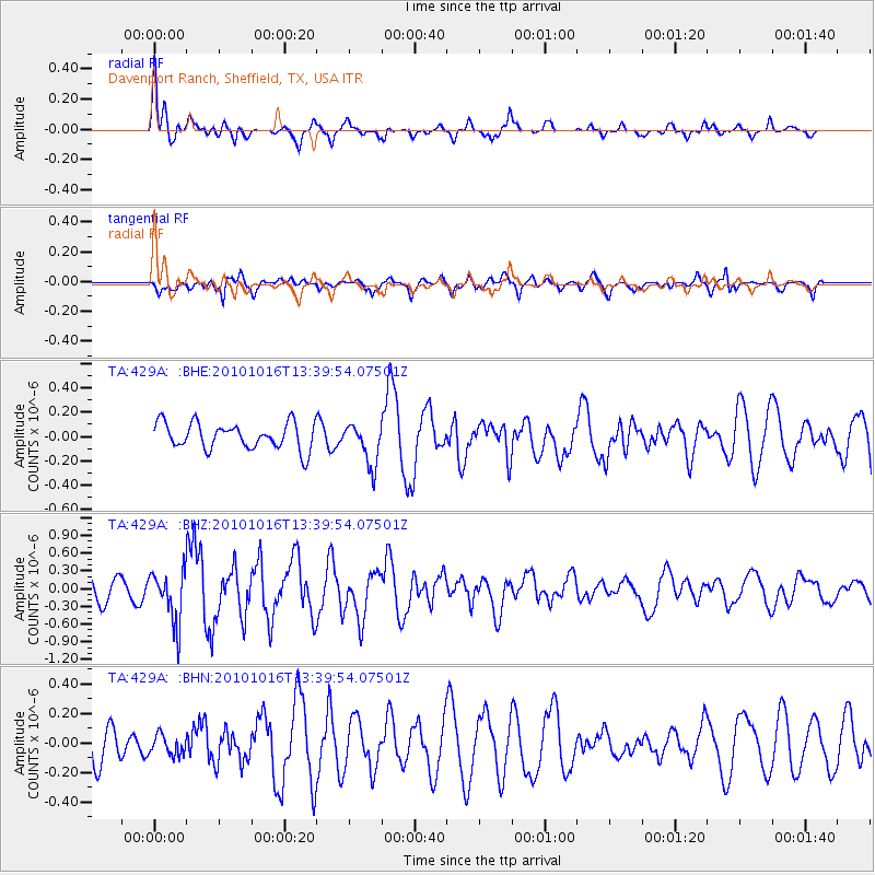
Signal To Noise
| Channel | StoN | STA | LTA |
| TA:429A: :BHZ:20101016T13:39:54.07501Z | 1.9970481 | 4.3695766E-7 | 2.1880177E-7 |
| TA:429A: :BHN:20101016T13:39:54.07501Z | 0.6171192 | 6.7495165E-8 | 1.0937136E-7 |
| TA:429A: :BHE:20101016T13:39:54.07501Z | 1.6040784 | 1.7226976E-7 | 1.0739485E-7 |
| Arrivals |
| Ps | 5.7 SECOND |
| PpPs | 17 SECOND |
| PsPs/PpSs | 22 SECOND |


