You are here: Home > Network List > TA - USArray Transportable Network (new EarthScope stations) Stations List
> Station 431A Sonora, TX, USA > Earthquake Result Viewer
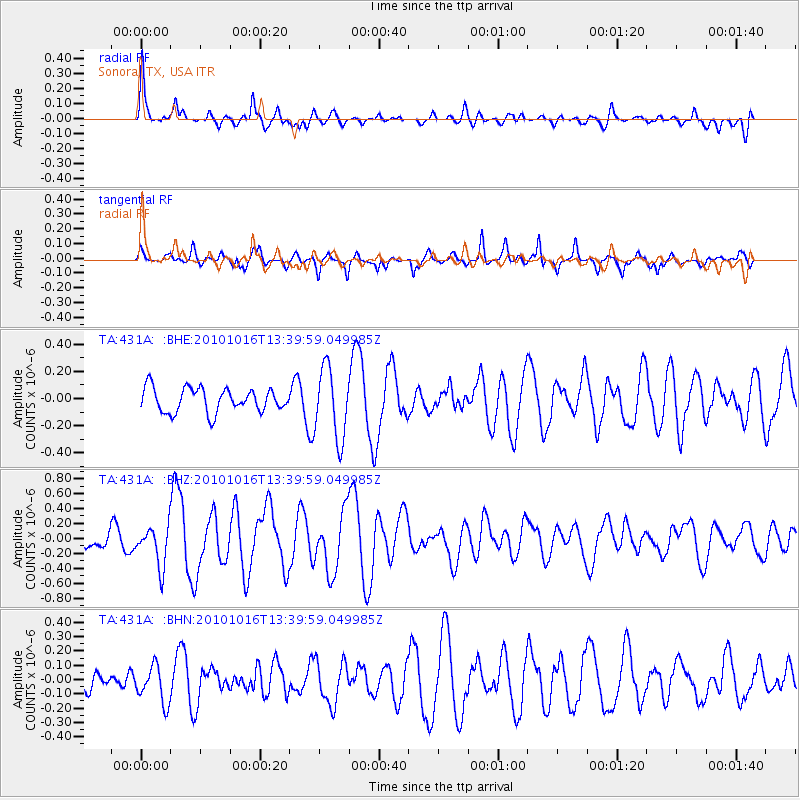
431A Sonora, TX, USA - Earthquake Result Viewer
*The percent match for this event was below the threshold and hence no stack was calculated.
| Earthquake location: |
Tonga Islands |
| Earthquake latitude/longitude: |
-20.5/-173.9 |
| Earthquake time(UTC): |
2010/10/16 (289) 13:27:45 GMT |
| Earthquake Depth: |
7.4 km |
| Earthquake Magnitude: |
5.7 MB, 5.7 MS, 5.6 MW, 5.6 MW |
| Earthquake Catalog/Contributor: |
WHDF/NEIC |
|
| Network: |
TA USArray Transportable Network (new EarthScope stations) |
| Station: |
431A Sonora, TX, USA |
| Lat/Lon: |
30.68 N/100.61 W |
| Elevation: |
700 m |
|
| Distance: |
86.8 deg |
| Az: |
55.739 deg |
| Baz: |
244.1 deg |
| Ray Param: |
$rayparam |
*The percent match for this event was below the threshold and hence was not used in the summary stack. |
|
| Radial Match: |
71.741356 % |
| Radial Bump: |
400 |
| Transverse Match: |
72.50688 % |
| Transverse Bump: |
400 |
| SOD ConfigId: |
339645 |
| Insert Time: |
2011-02-17 07:48:07.119 +0000 |
| GWidth: |
2.5 |
| Max Bumps: |
400 |
| Tol: |
0.001 |
|
Signal To Noise
| Channel | StoN | STA | LTA |
| TA:431A: :BHZ:20101016T13:39:59.049985Z | 2.5855927 | 2.687635E-7 | 1.0394657E-7 |
| TA:431A: :BHN:20101016T13:39:59.049985Z | 1.6386386 | 1.2978836E-7 | 7.9204995E-8 |
| TA:431A: :BHE:20101016T13:39:59.049985Z | 2.9779694 | 2.6057643E-7 | 8.7501384E-8 |
| Arrivals |
| Ps | |
| PpPs | |
| PsPs/PpSs | |


