You are here: Home > Network List > CI - Caltech Regional Seismic Network Stations List
> Station NEE2 Needles Airport > Earthquake Result Viewer
NEE2 Needles Airport - Earthquake Result Viewer
| Earthquake location: |
Mariana Islands |
| Earthquake latitude/longitude: |
19.1/145.4 |
| Earthquake time(UTC): |
2024/04/05 (096) 11:03:16 GMT |
| Earthquake Depth: |
222 km |
| Earthquake Magnitude: |
6.8 mww |
| Earthquake Catalog/Contributor: |
NEIC PDE/us |
|
| Network: |
CI Caltech Regional Seismic Network |
| Station: |
NEE2 Needles Airport |
| Lat/Lon: |
34.77 N/114.62 W |
| Elevation: |
271 m |
|
| Distance: |
87.2 deg |
| Az: |
54.269 deg |
| Baz: |
291.188 deg |
| Ray Param: |
0.04300712 |
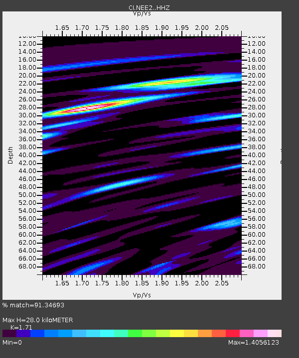
| Estimated Moho Depth: |
28.0 km |
| Estimated Crust Vp/Vs: |
1.71 |
| Assumed Crust Vp: |
6.276 km/s |
| Estimated Crust Vs: |
3.67 km/s |
| Estimated Crust Poisson's Ratio: |
0.24 |
|
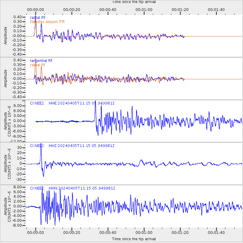
| Radial Match: |
91.34693 % |
| Radial Bump: |
400 |
| Transverse Match: |
72.90811 % |
| Transverse Bump: |
400 |
| SOD ConfigId: |
34025071 |
| Insert Time: |
2024-04-19 11:20:12.111 +0000 |
| GWidth: |
2.5 |
| Max Bumps: |
400 |
| Tol: |
0.001 |
|
Signal To Noise
| Channel | StoN | STA | LTA |
| CI:NEE2: :HHZ:20240405T11:15:05.949981Z | 65.93384 | 1.3116949E-5 | 1.9894107E-7 |
| CI:NEE2: :HHN:20240405T11:15:05.949981Z | 18.19109 | 2.922226E-6 | 1.6064051E-7 |
| CI:NEE2: :HHE:20240405T11:15:05.949981Z | 22.449486 | 4.0573495E-6 | 1.807324E-7 |
| Arrivals |
| Ps | 3.2 SECOND |
| PpPs | 12 SECOND |
| PsPs/PpSs | 15 SECOND |


