You are here: Home > Network List > TA - USArray Transportable Network (new EarthScope stations) Stations List
> Station 531A Rocksprings, TX, USA > Earthquake Result Viewer
531A Rocksprings, TX, USA - Earthquake Result Viewer

| Earthquake location: |
Tonga Islands |
| Earthquake latitude/longitude: |
-20.5/-173.9 |
| Earthquake time(UTC): |
2010/10/16 (289) 13:27:45 GMT |
| Earthquake Depth: |
7.4 km |
| Earthquake Magnitude: |
5.7 MB, 5.7 MS, 5.6 MW, 5.6 MW |
| Earthquake Catalog/Contributor: |
WHDF/NEIC |
|
| Network: |
TA USArray Transportable Network (new EarthScope stations) |
| Station: |
531A Rocksprings, TX, USA |
| Lat/Lon: |
30.16 N/100.55 W |
| Elevation: |
661 m |
|
| Distance: |
86.6 deg |
| Az: |
56.228 deg |
| Baz: |
244.159 deg |
| Ray Param: |
0.043912545 |
| Estimated Moho Depth: |
24.25 km |
| Estimated Crust Vp/Vs: |
1.60 |
| Assumed Crust Vp: |
6.38 km/s |
| Estimated Crust Vs: |
3.988 km/s |
| Estimated Crust Poisson's Ratio: |
0.18 |
|
| Radial Match: |
80.79173 % |
| Radial Bump: |
400 |
| Transverse Match: |
64.14805 % |
| Transverse Bump: |
376 |
| SOD ConfigId: |
339645 |
| Insert Time: |
2011-02-17 07:48:18.823 +0000 |
| GWidth: |
2.5 |
| Max Bumps: |
400 |
| Tol: |
0.001 |
|
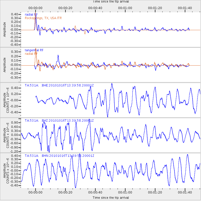
Signal To Noise
| Channel | StoN | STA | LTA |
| TA:531A: :BHZ:20101016T13:39:58.20001Z | 2.6984856 | 4.1887515E-7 | 1.55226E-7 |
| TA:531A: :BHN:20101016T13:39:58.20001Z | 1.5071565 | 2.4586313E-7 | 1.6313047E-7 |
| TA:531A: :BHE:20101016T13:39:58.20001Z | 2.5621853 | 1.7291106E-7 | 6.748577E-8 |
| Arrivals |
| Ps | 2.3 SECOND |
| PpPs | 9.6 SECOND |
| PsPs/PpSs | 12 SECOND |


