You are here: Home > Network List > TA - USArray Transportable Network (new EarthScope stations) Stations List
> Station 532A Rocksprings, TX, USA > Earthquake Result Viewer
532A Rocksprings, TX, USA - Earthquake Result Viewer
| Earthquake location: |
Tonga Islands |
| Earthquake latitude/longitude: |
-20.5/-173.9 |
| Earthquake time(UTC): |
2010/10/16 (289) 13:27:45 GMT |
| Earthquake Depth: |
7.4 km |
| Earthquake Magnitude: |
5.7 MB, 5.7 MS, 5.6 MW, 5.6 MW |
| Earthquake Catalog/Contributor: |
WHDF/NEIC |
|
| Network: |
TA USArray Transportable Network (new EarthScope stations) |
| Station: |
532A Rocksprings, TX, USA |
| Lat/Lon: |
30.13 N/99.90 W |
| Elevation: |
703 m |
|
| Distance: |
87.1 deg |
| Az: |
56.502 deg |
| Baz: |
244.495 deg |
| Ray Param: |
0.04355706 |
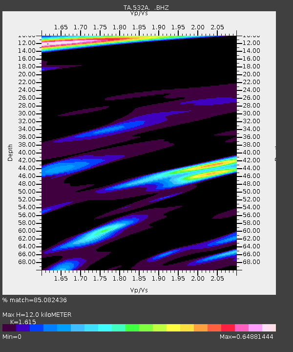
| Estimated Moho Depth: |
12.0 km |
| Estimated Crust Vp/Vs: |
1.62 |
| Assumed Crust Vp: |
6.498 km/s |
| Estimated Crust Vs: |
4.023 km/s |
| Estimated Crust Poisson's Ratio: |
0.19 |
|
| Radial Match: |
85.082436 % |
| Radial Bump: |
349 |
| Transverse Match: |
70.95626 % |
| Transverse Bump: |
400 |
| SOD ConfigId: |
339645 |
| Insert Time: |
2011-02-17 07:48:30.808 +0000 |
| GWidth: |
2.5 |
| Max Bumps: |
400 |
| Tol: |
0.001 |
|
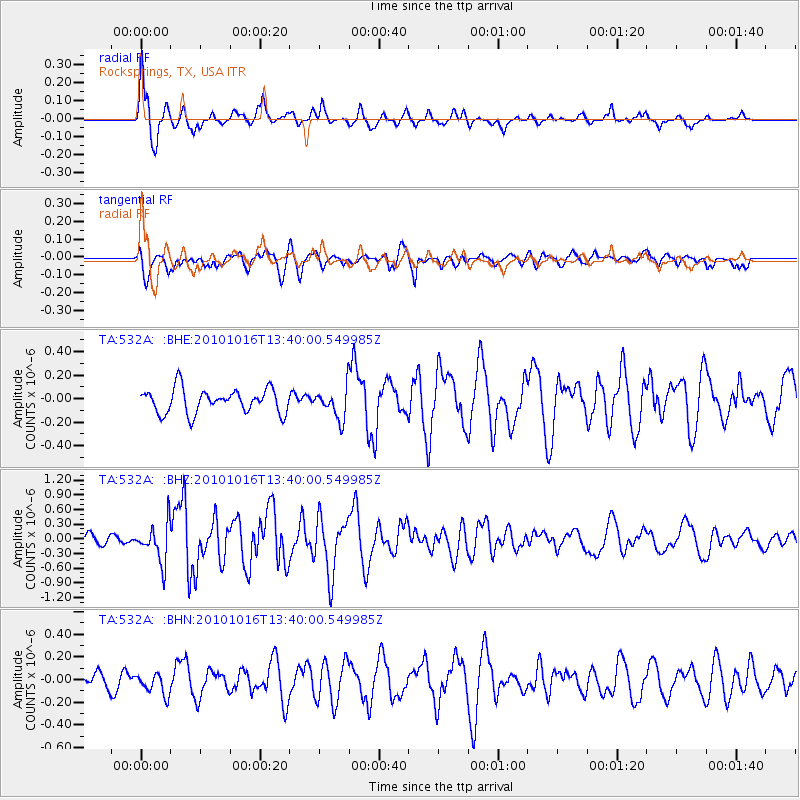
Signal To Noise
| Channel | StoN | STA | LTA |
| TA:532A: :BHZ:20101016T13:40:00.549985Z | 3.6793802 | 3.9787741E-7 | 1.0813707E-7 |
| TA:532A: :BHN:20101016T13:40:00.549985Z | 0.9235101 | 9.430899E-8 | 1.0212015E-7 |
| TA:532A: :BHE:20101016T13:40:00.549985Z | 1.2801121 | 1.3200625E-7 | 1.0312085E-7 |
| Arrivals |
| Ps | 1.2 SECOND |
| PpPs | 4.7 SECOND |
| PsPs/PpSs | 5.9 SECOND |


