You are here: Home > Network List > CN - Canadian National Seismograph Network Stations List
> Station HYT Haines Jct., YT, CA > Earthquake Result Viewer
HYT Haines Jct., YT, CA - Earthquake Result Viewer
| Earthquake location: |
Mariana Islands |
| Earthquake latitude/longitude: |
19.1/145.4 |
| Earthquake time(UTC): |
2024/04/05 (096) 11:03:16 GMT |
| Earthquake Depth: |
222 km |
| Earthquake Magnitude: |
6.8 mww |
| Earthquake Catalog/Contributor: |
NEIC PDE/us |
|
| Network: |
CN Canadian National Seismograph Network |
| Station: |
HYT Haines Jct., YT, CA |
| Lat/Lon: |
60.83 N/137.51 W |
| Elevation: |
1373 m |
|
| Distance: |
67.2 deg |
| Az: |
31.195 deg |
| Baz: |
268.473 deg |
| Ray Param: |
0.05644488 |
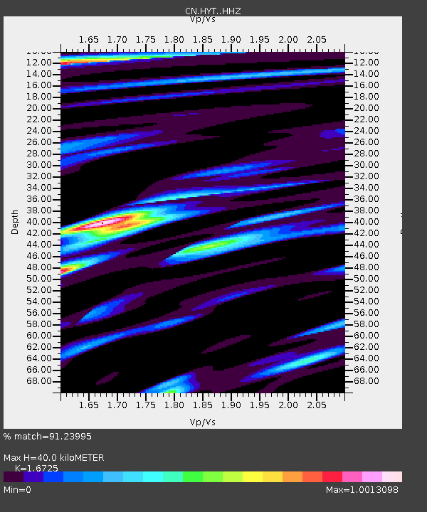
| Estimated Moho Depth: |
40.0 km |
| Estimated Crust Vp/Vs: |
1.67 |
| Assumed Crust Vp: |
6.566 km/s |
| Estimated Crust Vs: |
3.926 km/s |
| Estimated Crust Poisson's Ratio: |
0.22 |
|
| Radial Match: |
91.23995 % |
| Radial Bump: |
354 |
| Transverse Match: |
89.418465 % |
| Transverse Bump: |
400 |
| SOD ConfigId: |
34025071 |
| Insert Time: |
2024-04-19 11:22:02.719 +0000 |
| GWidth: |
2.5 |
| Max Bumps: |
400 |
| Tol: |
0.001 |
|

Signal To Noise
| Channel | StoN | STA | LTA |
| CN:HYT: :HHZ:20240405T11:13:15.829986Z | 56.964638 | 1.0484071E-5 | 1.8404525E-7 |
| CN:HYT: :HHN:20240405T11:13:15.829986Z | 11.886765 | 2.7106466E-6 | 2.2803906E-7 |
| CN:HYT: :HHE:20240405T11:13:15.829986Z | 14.241383 | 3.6051963E-6 | 2.531493E-7 |
| Arrivals |
| Ps | 4.3 SECOND |
| PpPs | 16 SECOND |
| PsPs/PpSs | 20 SECOND |


