You are here: Home > Network List > TA - USArray Transportable Network (new EarthScope stations) Stations List
> Station 331A San Angelo, TX, USA > Earthquake Result Viewer
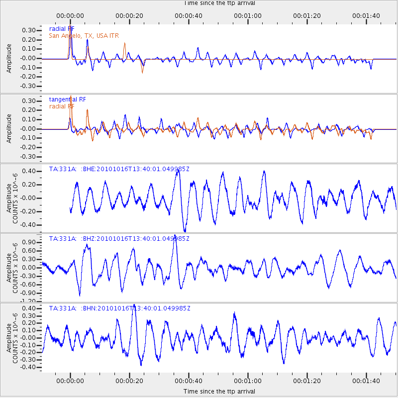
331A San Angelo, TX, USA - Earthquake Result Viewer
*The percent match for this event was below the threshold and hence no stack was calculated.
| Earthquake location: |
Tonga Islands |
| Earthquake latitude/longitude: |
-20.5/-173.9 |
| Earthquake time(UTC): |
2010/10/16 (289) 13:27:45 GMT |
| Earthquake Depth: |
7.4 km |
| Earthquake Magnitude: |
5.7 MB, 5.7 MS, 5.6 MW, 5.6 MW |
| Earthquake Catalog/Contributor: |
WHDF/NEIC |
|
| Network: |
TA USArray Transportable Network (new EarthScope stations) |
| Station: |
331A San Angelo, TX, USA |
| Lat/Lon: |
31.31 N/100.43 W |
| Elevation: |
615 m |
|
| Distance: |
87.2 deg |
| Az: |
55.245 deg |
| Baz: |
244.168 deg |
| Ray Param: |
$rayparam |
*The percent match for this event was below the threshold and hence was not used in the summary stack. |
|
| Radial Match: |
70.31039 % |
| Radial Bump: |
363 |
| Transverse Match: |
53.32579 % |
| Transverse Bump: |
338 |
| SOD ConfigId: |
339645 |
| Insert Time: |
2011-02-17 07:49:05.884 +0000 |
| GWidth: |
2.5 |
| Max Bumps: |
400 |
| Tol: |
0.001 |
|
Signal To Noise
| Channel | StoN | STA | LTA |
| TA:331A: :BHZ:20101016T13:40:01.049985Z | 3.8216677 | 4.0825648E-7 | 1.0682679E-7 |
| TA:331A: :BHN:20101016T13:40:01.049985Z | 1.1779984 | 9.0429516E-8 | 7.67654E-8 |
| TA:331A: :BHE:20101016T13:40:01.049985Z | 0.8611404 | 1.06413644E-7 | 1.2357293E-7 |
| Arrivals |
| Ps | |
| PpPs | |
| PsPs/PpSs | |


