You are here: Home > Network List > CN - Canadian National Seismograph Network Stations List
> Station PTRF Port Renfrew PTRF, BC, CA > Earthquake Result Viewer
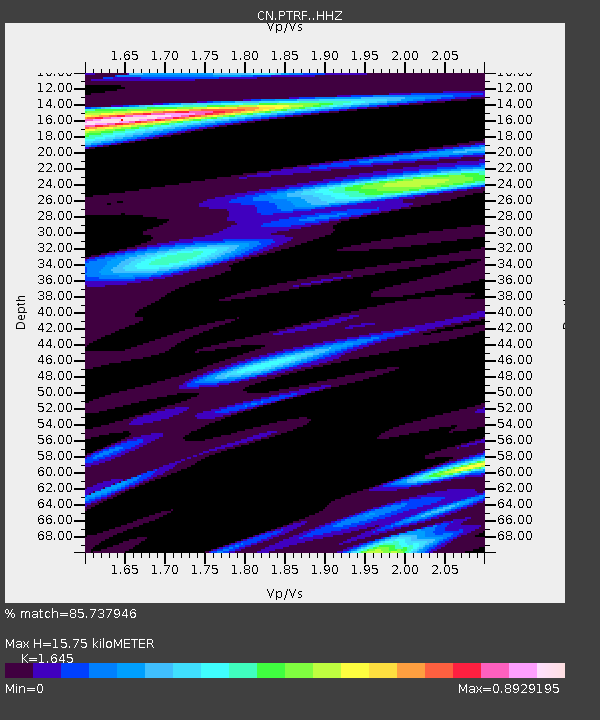
PTRF Port Renfrew PTRF, BC, CA - Earthquake Result Viewer
| Earthquake location: |
Mariana Islands |
| Earthquake latitude/longitude: |
19.1/145.4 |
| Earthquake time(UTC): |
2024/04/05 (096) 11:03:16 GMT |
| Earthquake Depth: |
222 km |
| Earthquake Magnitude: |
6.8 mww |
| Earthquake Catalog/Contributor: |
NEIC PDE/us |
|
| Network: |
CN Canadian National Seismograph Network |
| Station: |
PTRF Port Renfrew PTRF, BC, CA |
| Lat/Lon: |
48.54 N/124.41 W |
| Elevation: |
164 m |
|
| Distance: |
76.1 deg |
| Az: |
43.212 deg |
| Baz: |
283.02 deg |
| Ray Param: |
0.05066573 |
| Estimated Moho Depth: |
15.75 km |
| Estimated Crust Vp/Vs: |
1.64 |
| Assumed Crust Vp: |
6.391 km/s |
| Estimated Crust Vs: |
3.885 km/s |
| Estimated Crust Poisson's Ratio: |
0.21 |
|
| Radial Match: |
85.737946 % |
| Radial Bump: |
382 |
| Transverse Match: |
78.09605 % |
| Transverse Bump: |
400 |
| SOD ConfigId: |
34025071 |
| Insert Time: |
2024-04-19 11:22:35.790 +0000 |
| GWidth: |
2.5 |
| Max Bumps: |
400 |
| Tol: |
0.001 |
|

Signal To Noise
| Channel | StoN | STA | LTA |
| CN:PTRF: :HHZ:20240405T11:14:08.230011Z | 14.6283455 | 1.2052499E-5 | 8.2391404E-7 |
| CN:PTRF: :HHN:20240405T11:14:08.230011Z | 5.133545 | 2.0545624E-6 | 4.0022292E-7 |
| CN:PTRF: :HHE:20240405T11:14:08.230011Z | 6.6999626 | 4.1367143E-6 | 6.174235E-7 |
| Arrivals |
| Ps | 1.6 SECOND |
| PpPs | 6.3 SECOND |
| PsPs/PpSs | 7.9 SECOND |


