You are here: Home > Network List > TA - USArray Transportable Network (new EarthScope stations) Stations List
> Station 130A Snyder, TX, USA > Earthquake Result Viewer
130A Snyder, TX, USA - Earthquake Result Viewer
| Earthquake location: |
Tonga Islands |
| Earthquake latitude/longitude: |
-20.5/-173.9 |
| Earthquake time(UTC): |
2010/10/16 (289) 13:27:45 GMT |
| Earthquake Depth: |
7.4 km |
| Earthquake Magnitude: |
5.7 MB, 5.7 MS, 5.6 MW, 5.6 MW |
| Earthquake Catalog/Contributor: |
WHDF/NEIC |
|
| Network: |
TA USArray Transportable Network (new EarthScope stations) |
| Station: |
130A Snyder, TX, USA |
| Lat/Lon: |
32.60 N/100.97 W |
| Elevation: |
676 m |
|
| Distance: |
87.4 deg |
| Az: |
53.889 deg |
| Baz: |
243.82 deg |
| Ray Param: |
0.043372065 |
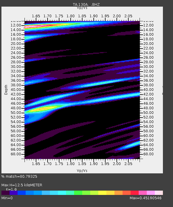
| Estimated Moho Depth: |
12.5 km |
| Estimated Crust Vp/Vs: |
1.60 |
| Assumed Crust Vp: |
6.426 km/s |
| Estimated Crust Vs: |
4.016 km/s |
| Estimated Crust Poisson's Ratio: |
0.18 |
|
| Radial Match: |
80.79325 % |
| Radial Bump: |
400 |
| Transverse Match: |
79.32006 % |
| Transverse Bump: |
345 |
| SOD ConfigId: |
339645 |
| Insert Time: |
2011-02-17 07:49:22.080 +0000 |
| GWidth: |
2.5 |
| Max Bumps: |
400 |
| Tol: |
0.001 |
|
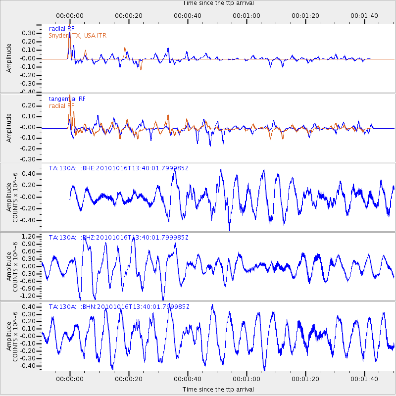
Signal To Noise
| Channel | StoN | STA | LTA |
| TA:130A: :BHZ:20101016T13:40:01.799985Z | 2.8276222 | 5.9283116E-7 | 2.0965713E-7 |
| TA:130A: :BHN:20101016T13:40:01.799985Z | 0.94581133 | 1.2506618E-7 | 1.3223165E-7 |
| TA:130A: :BHE:20101016T13:40:01.799985Z | 2.3999789 | 2.0364169E-7 | 8.485145E-8 |
| Arrivals |
| Ps | 1.2 SECOND |
| PpPs | 4.9 SECOND |
| PsPs/PpSs | 6.1 SECOND |


