You are here: Home > Network List > GO - National Seismic Network of Georgia Stations List
> Station MTAG MTAG,Georgia > Earthquake Result Viewer
MTAG MTAG,Georgia - Earthquake Result Viewer
| Earthquake location: |
Mariana Islands |
| Earthquake latitude/longitude: |
19.1/145.4 |
| Earthquake time(UTC): |
2024/04/05 (096) 11:03:16 GMT |
| Earthquake Depth: |
222 km |
| Earthquake Magnitude: |
6.8 mww |
| Earthquake Catalog/Contributor: |
NEIC PDE/us |
|
| Network: |
GO National Seismic Network of Georgia |
| Station: |
MTAG MTAG,Georgia |
| Lat/Lon: |
42.09 N/45.16 E |
| Elevation: |
728 m |
|
| Distance: |
84.7 deg |
| Az: |
312.64 deg |
| Baz: |
69.16 deg |
| Ray Param: |
0.04475537 |
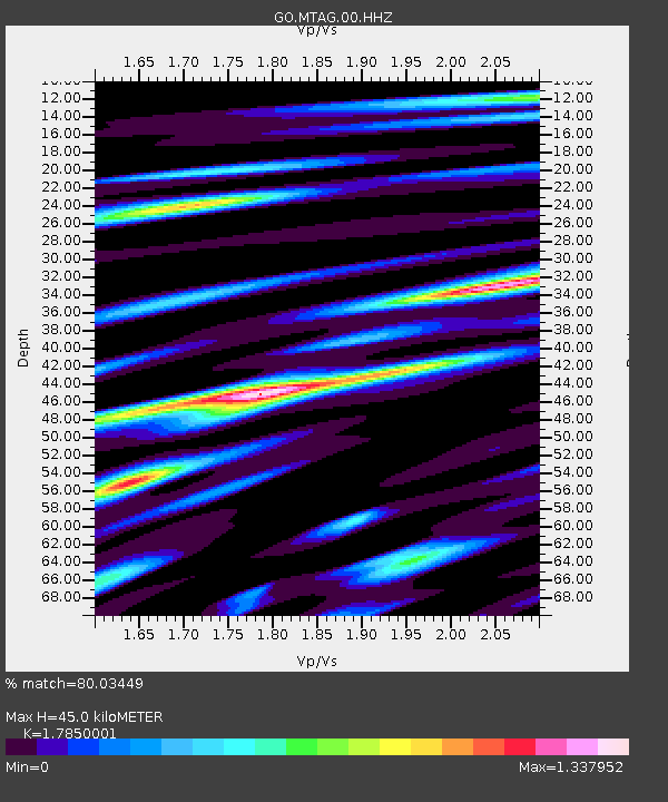
| Estimated Moho Depth: |
45.0 km |
| Estimated Crust Vp/Vs: |
1.79 |
| Assumed Crust Vp: |
6.142 km/s |
| Estimated Crust Vs: |
3.441 km/s |
| Estimated Crust Poisson's Ratio: |
0.27 |
|
| Radial Match: |
80.03449 % |
| Radial Bump: |
400 |
| Transverse Match: |
78.79182 % |
| Transverse Bump: |
400 |
| SOD ConfigId: |
34025071 |
| Insert Time: |
2024-04-19 11:24:51.806 +0000 |
| GWidth: |
2.5 |
| Max Bumps: |
400 |
| Tol: |
0.001 |
|

Signal To Noise
| Channel | StoN | STA | LTA |
| GO:MTAG:00:HHZ:20240405T11:14:53.990021Z | 115.007416 | 8.306381E-6 | 7.222474E-8 |
| GO:MTAG:00:HHN:20240405T11:14:53.990021Z | 39.00409 | 3.150807E-6 | 8.078146E-8 |
| GO:MTAG:00:HHE:20240405T11:14:53.990021Z | 42.62806 | 3.5045355E-6 | 8.221193E-8 |
| Arrivals |
| Ps | 5.9 SECOND |
| PpPs | 20 SECOND |
| PsPs/PpSs | 26 SECOND |


