You are here: Home > Network List > TA - USArray Transportable Network (new EarthScope stations) Stations List
> Station R29A Marienthal, KS, USA > Earthquake Result Viewer
R29A Marienthal, KS, USA - Earthquake Result Viewer
| Earthquake location: |
Tonga Islands |
| Earthquake latitude/longitude: |
-20.5/-173.9 |
| Earthquake time(UTC): |
2010/10/16 (289) 13:27:45 GMT |
| Earthquake Depth: |
7.4 km |
| Earthquake Magnitude: |
5.7 MB, 5.7 MS, 5.6 MW, 5.6 MW |
| Earthquake Catalog/Contributor: |
WHDF/NEIC |
|
| Network: |
TA USArray Transportable Network (new EarthScope stations) |
| Station: |
R29A Marienthal, KS, USA |
| Lat/Lon: |
38.42 N/101.14 W |
| Elevation: |
957 m |
|
| Distance: |
89.8 deg |
| Az: |
48.611 deg |
| Baz: |
243.591 deg |
| Ray Param: |
0.041717265 |
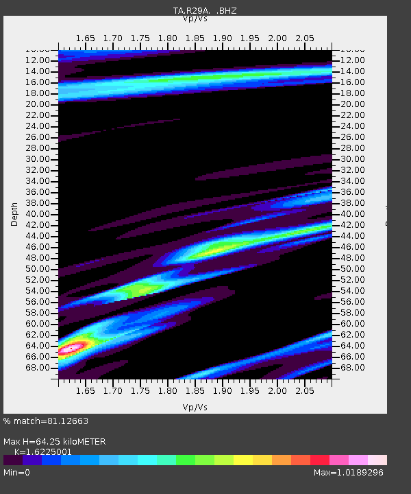
| Estimated Moho Depth: |
64.25 km |
| Estimated Crust Vp/Vs: |
1.62 |
| Assumed Crust Vp: |
6.483 km/s |
| Estimated Crust Vs: |
3.995 km/s |
| Estimated Crust Poisson's Ratio: |
0.19 |
|
| Radial Match: |
81.12663 % |
| Radial Bump: |
400 |
| Transverse Match: |
52.253887 % |
| Transverse Bump: |
339 |
| SOD ConfigId: |
339645 |
| Insert Time: |
2011-02-17 07:50:04.122 +0000 |
| GWidth: |
2.5 |
| Max Bumps: |
400 |
| Tol: |
0.001 |
|

Signal To Noise
| Channel | StoN | STA | LTA |
| TA:R29A: :BHZ:20101016T13:40:13.349973Z | 1.1652288 | 2.1884665E-7 | 1.878143E-7 |
| TA:R29A: :BHN:20101016T13:40:13.349973Z | 0.8753522 | 2.2874427E-7 | 2.6131684E-7 |
| TA:R29A: :BHE:20101016T13:40:13.349973Z | 1.616543 | 4.1264843E-7 | 2.5526597E-7 |
| Arrivals |
| Ps | 6.3 SECOND |
| PpPs | 25 SECOND |
| PsPs/PpSs | 32 SECOND |


