You are here: Home > Network List > GS - US Geological Survey Networks Stations List
> Station ASA2 ASA2 > Earthquake Result Viewer
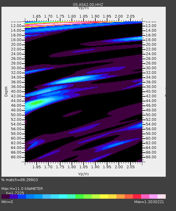
ASA2 ASA2 - Earthquake Result Viewer
| Earthquake location: |
Mariana Islands |
| Earthquake latitude/longitude: |
19.1/145.4 |
| Earthquake time(UTC): |
2024/04/05 (096) 11:03:16 GMT |
| Earthquake Depth: |
222 km |
| Earthquake Magnitude: |
6.8 mww |
| Earthquake Catalog/Contributor: |
NEIC PDE/us |
|
| Network: |
GS US Geological Survey Networks |
| Station: |
ASA2 ASA2 |
| Lat/Lon: |
34.95 N/106.46 W |
| Elevation: |
1830 m |
|
| Distance: |
93.2 deg |
| Az: |
51.432 deg |
| Baz: |
295.845 deg |
| Ray Param: |
0.041163046 |
| Estimated Moho Depth: |
11.0 km |
| Estimated Crust Vp/Vs: |
1.72 |
| Assumed Crust Vp: |
6.502 km/s |
| Estimated Crust Vs: |
3.774 km/s |
| Estimated Crust Poisson's Ratio: |
0.25 |
|
| Radial Match: |
89.29903 % |
| Radial Bump: |
347 |
| Transverse Match: |
75.45831 % |
| Transverse Bump: |
400 |
| SOD ConfigId: |
34025071 |
| Insert Time: |
2024-04-19 11:25:07.583 +0000 |
| GWidth: |
2.5 |
| Max Bumps: |
400 |
| Tol: |
0.001 |
|

Signal To Noise
| Channel | StoN | STA | LTA |
| GS:ASA2:00:HHZ:20240405T11:15:34.149017Z | 52.6401 | 5.8608434E-6 | 1.11338004E-7 |
| GS:ASA2:00:HH1:20240405T11:15:34.149017Z | 4.5659986 | 6.258427E-7 | 1.370659E-7 |
| GS:ASA2:00:HH2:20240405T11:15:34.149017Z | 10.2383585 | 1.5409871E-6 | 1.5051116E-7 |
| Arrivals |
| Ps | 1.2 SECOND |
| PpPs | 4.5 SECOND |
| PsPs/PpSs | 5.8 SECOND |


