You are here: Home > Network List > TA - USArray Transportable Network (new EarthScope stations) Stations List
> Station N02D Trinity Center, CA, USA > Earthquake Result Viewer
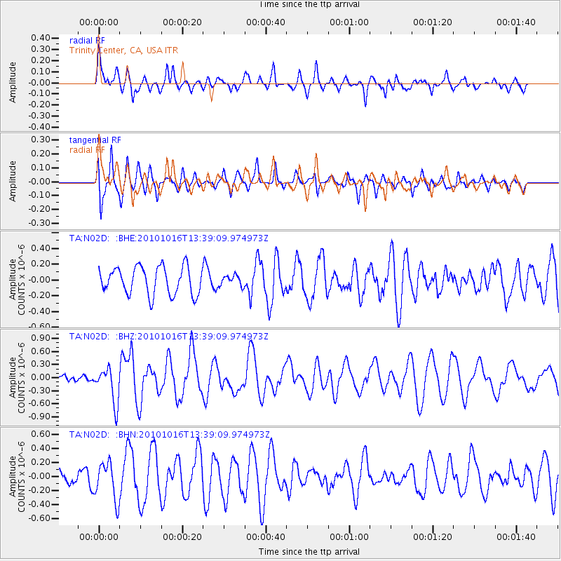
N02D Trinity Center, CA, USA - Earthquake Result Viewer
*The percent match for this event was below the threshold and hence no stack was calculated.
| Earthquake location: |
Tonga Islands |
| Earthquake latitude/longitude: |
-20.5/-173.9 |
| Earthquake time(UTC): |
2010/10/16 (289) 13:27:45 GMT |
| Earthquake Depth: |
7.4 km |
| Earthquake Magnitude: |
5.7 MB, 5.7 MS, 5.6 MW, 5.6 MW |
| Earthquake Catalog/Contributor: |
WHDF/NEIC |
|
| Network: |
TA USArray Transportable Network (new EarthScope stations) |
| Station: |
N02D Trinity Center, CA, USA |
| Lat/Lon: |
40.97 N/122.71 W |
| Elevation: |
937 m |
|
| Distance: |
77.4 deg |
| Az: |
37.208 deg |
| Baz: |
228.492 deg |
| Ray Param: |
$rayparam |
*The percent match for this event was below the threshold and hence was not used in the summary stack. |
|
| Radial Match: |
52.012505 % |
| Radial Bump: |
400 |
| Transverse Match: |
62.126423 % |
| Transverse Bump: |
400 |
| SOD ConfigId: |
339645 |
| Insert Time: |
2011-02-17 07:52:11.003 +0000 |
| GWidth: |
2.5 |
| Max Bumps: |
400 |
| Tol: |
0.001 |
|
Signal To Noise
| Channel | StoN | STA | LTA |
| TA:N02D: :BHZ:20101016T13:39:09.974973Z | 3.7602456 | 4.2170777E-7 | 1.12148996E-7 |
| TA:N02D: :BHN:20101016T13:39:09.974973Z | 2.372531 | 2.7435104E-7 | 1.1563644E-7 |
| TA:N02D: :BHE:20101016T13:39:09.974973Z | 0.36468858 | 6.377698E-8 | 1.7488065E-7 |
| Arrivals |
| Ps | |
| PpPs | |
| PsPs/PpSs | |


