You are here: Home > Network List > N4 - Central and EAstern US Network Stations List
> Station K22A Casper, WY, USA > Earthquake Result Viewer
K22A Casper, WY, USA - Earthquake Result Viewer
| Earthquake location: |
Mariana Islands |
| Earthquake latitude/longitude: |
19.1/145.4 |
| Earthquake time(UTC): |
2024/04/05 (096) 11:03:16 GMT |
| Earthquake Depth: |
222 km |
| Earthquake Magnitude: |
6.8 mww |
| Earthquake Catalog/Contributor: |
NEIC PDE/us |
|
| Network: |
N4 Central and EAstern US Network |
| Station: |
K22A Casper, WY, USA |
| Lat/Lon: |
42.65 N/106.52 W |
| Elevation: |
1686 m |
|
| Distance: |
89.8 deg |
| Az: |
44.532 deg |
| Baz: |
295.99 deg |
| Ray Param: |
0.04169822 |
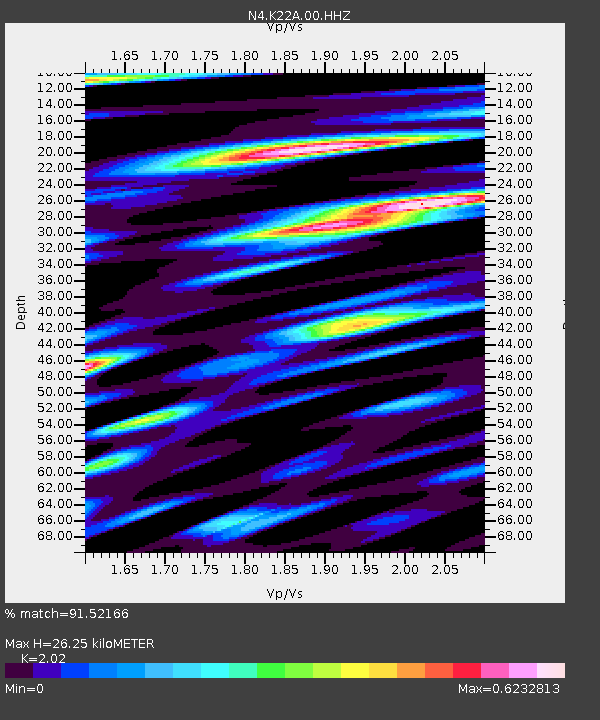
| Estimated Moho Depth: |
26.25 km |
| Estimated Crust Vp/Vs: |
2.02 |
| Assumed Crust Vp: |
6.178 km/s |
| Estimated Crust Vs: |
3.059 km/s |
| Estimated Crust Poisson's Ratio: |
0.34 |
|
| Radial Match: |
91.52166 % |
| Radial Bump: |
400 |
| Transverse Match: |
76.47123 % |
| Transverse Bump: |
400 |
| SOD ConfigId: |
34025071 |
| Insert Time: |
2024-04-19 11:29:22.792 +0000 |
| GWidth: |
2.5 |
| Max Bumps: |
400 |
| Tol: |
0.001 |
|

Signal To Noise
| Channel | StoN | STA | LTA |
| N4:K22A:00:HHZ:20240405T11:15:18.449005Z | 62.655506 | 1.0584859E-5 | 1.6893742E-7 |
| N4:K22A:00:HH1:20240405T11:15:18.449005Z | 9.469216 | 2.2292104E-6 | 2.3541655E-7 |
| N4:K22A:00:HH2:20240405T11:15:18.449005Z | 17.374271 | 3.4405123E-6 | 1.980234E-7 |
| Arrivals |
| Ps | 4.4 SECOND |
| PpPs | 13 SECOND |
| PsPs/PpSs | 17 SECOND |


